


The dimension on the Egyptian Ancient Alphabet is so exciting that my simplicity in my own life rounds a sorting filed. The absolute of just this proof to audit in an on-going write will indeed deliver the Milky Way at just a street on the quote unquote Monterey!! To have the complete fathom at math I chill this type written tab as merely the time it takes to clock a pen. What a reward for the worth to speak and as the world is only a seep this treasure of a talk leaps from the page to my fingers. Oh for the shock in a wonderful day of strength and display.
The Ancient Greek Alphabet and it's reference in just adding does subtract knowledge lending towards the not the effort of but rather the difference. A trace? No, as the form to number on action creates yet another dimension on a farther platform. To negate the difference as only reward would certainly discount the event of today April 10, 2018 as Earth has had many a year that causes my arithmetic to know, understand and comprehend that it has not been able to communicate at the speed of only light. Truth to counter on the grain of sand did change to salted though, interesting.
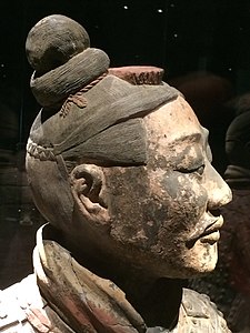
Stifling humanity? No, it seems that humanity at-large does not seem interested in compiling more than cause to aspect forgetting effect as yet? The Ancient Chinese still frames first to the tangible statute following/compiling the ancient find of both the Forgotten City and the buried soldiers i.e. Terracota Army leaving a quality not quantity to dicipher to add to the lips of Time as in the Ages in Times/Time Periods.
1.) Should people or would it be the Earth at-hand take it as reservation or search, the identity of actionable residence of the Wormhole?
2.) Should the math to toss a Pandora on freeze as weighted, proper or important?
3.) What brings the past mathematicians to the pen?
4.) While in an environment (the U.S.A.) that discourages in person such tremble of excitement while on television the Shows develop searches for such excitement, and, are constantly asking the 'what if' question, does the bearing of such require more than this note?
Meanwhile on the opportunity of dreamt, the wonderful fact, an old Trainer has possible time to continue my training (three-day Eventing) and I bravo this verse to say that I am grateful for all the flat work invested that brought me to this posture today, and at this very moment the pause to say I believe that I will ask. Although the time spent on all that dressage in my youth was indeed pain-staking it is the now that brings type to my smile. A grin in glowing form must be at worth of such demand, for should the avenue present such opportunity than it is left to hard work and discipline. Simply stating a sure word to say that I dreamed of going to the 1984 Olympics and now the formal dreamt may indeed realm more than a lost canter. To know of these formula's, to know that hard work pays-off, to smile for more than the best of the best of, these comprehended are the moments that I introduce to myself worth.
Character and strength put forward by training of my entire life has made today a good day and for that I thank once again all those I have ever met or been fortunate enough to have had a conversation. Might all the creative idea's, dreams and laughter giggle your lives to delighted with your favorite dream of past to fill your life today, the 11th of April 2018!!
April 11, 2018 5:30 PM
Monterey, California
| City of Monterey | |||
|---|---|---|---|
| City | |||

|
|||
|
|||
| Nickname(s): Language Capital of the World,[1] California's "First" City |
|||
 Location of Monterey, California |
|||

City of Monterey
Location in the United States
|
|||
| Coordinates: 36°36′N 121°54′WCoordinates: 36°36′N 121°54′W | |||
| Country | |||
| State | |||
| County | Monterey | ||
| Incorporated | June 14, 1890[2] | ||
| Named for | Gaspar de Zúñiga, 5th Count of Monterrey | ||
| Government | |||
| • Type | Council-manager | ||
| • City council[6] | Mayor Clyde Roberson Vice Mayor Alan Haffa Timothy Barrett Libby Downey Ed Smith |
||
| • Interim City Manager | Hans Uslar[3] | ||
| • State senator | Bill Monning (D)[4] | ||
| • Assemblymember | Mark Stone (D)[4] | ||
| • U. S. rep. | Jimmy Panetta (D)[5] | ||
| Area[7] | |||
| • Total | 12.25 sq mi (31.74 km2) | ||
| • Land | 8.67 sq mi (22.47 km2) | ||
| • Water | 3.58 sq mi (9.27 km2) 28.03% | ||
| Elevation[8] | 26 ft (8 m) | ||
| Population (2010)[9] | |||
| • Total | 27,810 | ||
| • Estimate (2016)[10] | 28,454 | ||
| • Density | 3,280.38/sq mi (1,266.54/km2) | ||
| Time zone | Pacific (UTC−8) | ||
| • Summer (DST) | PDT (UTC−7) | ||
| ZIP codes | 93940–93944 | ||
| Area code | 831 | ||
| FIPS code | 06-48872[8] | ||
| GNIS feature IDs | 1659762, 2411145 | ||
| Website | www |
||


Monterey was the capital of Alta California under both Spain and Mexico. It was the only port of entry for taxable goods in California. In 1846, the U.S. flag was raised over the Customs House, and California became part of the United States after the Mexican–American War.
The city had California's first theater, public building, public library, publicly funded school, printing press, and newspaper. The city and surrounding area have attracted artists since the late 19th century and many celebrated painters and writers have lived there. Until the 1950s, there was an abundant fishery.
Among Monterey's notable present-day attractions are the Monterey Bay Aquarium, Cannery Row, Fisherman's Wharf and the annual Monterey Jazz Festival.
Contents
History
Native American period
Long before the arrival of Spanish explorers, the Rumsen Ohlone tribe, one of seven linguistically distinct Ohlone groups in California, inhabited the area now known as Monterey.[11] They subsisted by hunting, fishing and gathering food on and around the biologically rich Monterey Peninsula. Researchers have found a number of shell middens in the area and, based on the archaeological evidence, concluded the Ohlone's primary marine food consisted at various times of mussels and abalone.[12] A number of midden sites have been located along about 12 miles (19 km) of rocky coast on the Monterey Peninsula from the current site of Fishermans' Wharf in Monterey to Carmel.[13]
Royal Presidio Chapel circa 1934. The existing building dates to 1794.
Spanish period
In 1602, Spanish maritime explorer Sebastian Vizcaino recorded the name "Bahía de Monterrey", which has evolved into Monterey Bay. Vizcaino landed at the southern end of the bay and described a great port, suitable for use as an anchorage by southbound Manila galleons. Vizcaino also noted and named the "Point of Pines" (labeled on today's maps as "Point Pinos", the northernmost point of the Monterey Peninsula). All other uses of the name Monterey derive from Vizcaino's name for the bay. Variants of the city's name (from the Spanish Monterrey) are recorded as Monte Rey and Montery.[14]In 1769, the first European land exploration of Alta California, the Spanish Portolá expedition, traveled north from San Diego, seeking Vizcaino's "Port of Monterey" from 167 years earlier. For some reason, the explorers failed to recognize the place when they came to it on October 1, 1769. The party continued north as far as San Francisco Bay before turning back. On the return journey, they camped near one of Monterey's lagoons on November 27, still not convinced they had found the place Vizcaino had described. Franciscan missionary Juan Crespí noted in his diary, "We halted in sight of the Point of Pines (recognized, as was said, in the beginning of October) and camped near a small lagoon which has rather muddy water, but abounds in pasture and firewood."[15]
Portolá returned by land to Monterey the next year, having concluded that he must have been at Vizcaino's Port of Monterey after all. The land party was met at Monterey by Junípero Serra who traveled by sea. Portolá erected the Presidio of Monterey to defend the port and, on June 3, 1770, Serra founded the Cathedral of San Carlos Borromeo inside the presidio enclosure. Portolá returned to Mexico, replaced in Monterey by Captain Pedro Fages, who had been third in command on the exploratory expeditions. Fages became the second governor of Alta California, serving from 1770 to 1774.[16]
Serra's missionary aims soon came into conflict with Fages and the soldiers, and he moved the mission to Carmel the following year to gain greater independence from Fages. The existing wood and adobe building became the chapel for the Presidio.
Monterey became the capital of the "Province of Both Californias" in 1777, and the chapel was renamed the Royal Presidio Chapel. The original church was destroyed by fire in 1789 and replaced by the present sandstone structure. It was completed in 1794 by Indian labor.[17] In 1840, the chapel was rededicated to the patronage of Saint Charles Borromeo. The cathedral is the oldest continuously operating parish and the oldest stone building in California. It is also the oldest (and smallest) serving cathedral along with St. Louis Cathedral in New Orleans, Louisiana. It is the only existing presidio chapel in California and the only surviving building from the original Monterey Presidio.[18]
The city was originally the only port of entry for all taxable goods in California. All shipments into California by sea were required to go through the Custom House, the oldest governmental building in the state and California's Historic Landmark Number One.[19] Built in three phases, the Spanish began construction of the Custom House in 1814, the Mexican government completed the center section in 1827, and the United States government finished the lower end in 1846.[20]

Construction on the Custom House began in 1814 under Spanish rule. This photo dates from 1936.
Argentine invasion
On 24 November 1818 Argentine corsair Hippolyte Bouchard landed 7 km (4.3 mi) away from the Presidio of Monterey in a hidden creek. The fort resisted ineffectively, and after an hour of combat the Argentine flag flew over it.[21] The Argentines took the city for six days, during which time they stole the cattle and burned the fort, the artillery headquarters, the governor's residence and the Spanish houses. The town's residents were unharmed.[22]Mexican period
Mexico gained independence from Spain in 1821, but the civil and religious institutions of Alta California remained much the same until the 1830s, when the secularization of the missions converted most of the mission pasture lands into private land grant ranchos.Monterey was the site of the Battle of Monterey on July 7, 1846, during the Mexican-American War. It was on this date that John D. Sloat, Commodore in the United States Navy, raised the U.S. flag over the Monterey Custom House and claimed California for the United States.
In addition, many historic "firsts" occurred in Monterey. These include California's first theater, brick house, publicly funded school, public building, public library, and printing press, which printed The Californian, California's first newspaper. Larkin House,[23] one of Monterey State Historic Park’s National Historic Landmarks, built in the Mexican period by Thomas Oliver Larkin, is an early example of Monterey Colonial architecture. The old Custom House,[24] the historic district and the Royal Presidio Chapel are also National Historic Landmarks.[25] The Cooper-Molera Adobe is a National Trust Historic Site.[26]
State of California

Monterey Bay area in 1917
Monterey hosted California's first constitutional convention in 1849, which composed the documents necessary to apply to the United States for statehood. Today it houses a small museum, while adjacent buildings serve as the seat of local government, and the Monterey post office (opened in 1849).[14] Monterey was incorporated in 1889.[14]
Monterey had long been famous for the abundant fishery in Monterey Bay. That changed in the 1950s when the local fishery business collapsed due to overfishing. A few of the old fishermen's cabins from the early 20th century have been preserved as they originally stood along Cannery Row.
The city has a noteworthy history as a center for California painters in the late 19th and early 20th centuries. Such painters as Arthur Frank Mathews, Armin Hansen, Xavier Martinez, Rowena Meeks Abdy and Percy Gray lived or visited to pursue painting in the style of either En plein air or Tonalism.
In addition to painters, many noted authors have also lived in and around the Monterey area, including Robert Louis Stevenson, John Steinbeck, Ed Ricketts, Robinson Jeffers, Robert A. Heinlein, and Henry Miller.
More recently, Monterey has been recognized for its significant involvement in post-secondary learning of languages other than English and its major role in delivering translation and interpretation services around the world.
In November 1995, California Governor Pete Wilson proclaimed Monterey as "the Language Capital of the World".[1]
Geography
This section relies largely or entirely on a single source. (June 2012)
|

Birds along a rock sea wall near the Coast Guard Station, which borders the Monterey Bay National Marine Sanctuary.
Local soil is Quaternary Alluvium. Common soil series include the Baywood fine sand on the east side, Narlon loamy sand on the west side, Sheridan coarse sandy loam on hilly terrain, and the pale Tangair sand on hills supporting closed-cone pine habitat. The city is in a moderate to high seismic risk zone, the principal threat being the active San Andreas Fault approximately 26 miles (42 km) to the east. The Monterey Bay fault, which tracks three miles (4.8 km) to the north, is also active, as is the Palo Colorado fault seven miles (11.3 km) to the south. Also nearby, minor but potentially active, are the Berwick Canyon, Seaside, Tularcitos and Chupines faults.
Monterey Bay's maximum credible tsunami for a 100-year interval has been calculated as a wave nine feet (2.7 m) high. The considerable undeveloped area in the northwest part of the city has a high potential for landslides and erosion.
The city is adjacent to the Monterey Bay National Marine Sanctuary, a federally protected ocean area extending 276 mi (444 km) along the coast. Sometimes this sanctuary is confused with the local bay which is also termed Monterey Bay.
Soquel Canyon State Marine Conservation Area, Portuguese Ledge State Marine Conservation Area, Pacific Grove Marine Gardens State Marine Conservation Area, Lovers Point State Marine Reserve, Edward F. Ricketts State Marine Conservation Area and Asilomar State Marine Reserve are marine protected areas established by the state of California in Monterey Bay. Like underwater parks, these marine protected areas help conserve ocean wildlife and marine ecosystems.
The California sea otter, a threatened subspecies, inhabits the local Monterey Bay marine environment, and a field station of The Marine Mammal Center is located in Monterey to support sea rescue operations in this section of the California coast. The rare San Joaquin kit fox is found in Monterey's oak-forest and chaparral habitats. The chaparral, found mainly on the city's drier eastern slopes, hosts such plants as manzanita, chamise and ceanothus. Additional species of interest (that is, potential candidates for endangered species status) are the Salinas kangaroo rat and the silver-sided legless lizard.

Monterey Wharf and Harbor area
The closed-cone pine habitat is dominated by Monterey pine, Knobcone pine and Bishop pine, and contains the rare Monterey manzanita. In the early 20th century the botanist Willis Linn Jepson characterized Monterey Peninsula's forests as the "most important silva ever", and encouraged Samuel F.B. Morse (a century younger than the inventor Samuel F. B. Morse) of the Del Monte Properties Company Properties Company to explore the possibilities of preserving the unique forest communities.[28] The dune area is no less important, as it hosts endangered species such as the vascular plants Seaside birds beak, Hickman's potentilla and Eastwood's Ericameria. Rare plants also inhabit the chaparral: Hickman's onion, Yadon's piperia (Piperia yadonii) and Sandmat manzanita. Other rare plants in Monterey include Hutchinson's delphinium, Tidestrom lupine, Gardner's yampah and Monterey Knotweed, the latter perhaps already extinct.
Monterey's noise pollution has been mapped to define the principal sources of noise and to ascertain the areas of the population exposed to significant levels. Principal sources are the Monterey Regional Airport, State Route 1 and major arterial streets such as Munras Avenue, Fremont Street, Del Monte Boulevard, and Camino Aguajito. While most of Monterey is a quiet residential city, a moderate number of people in the northern part of the city are exposed to aircraft noise at levels in excess of 60 dB on the Community Noise Equivalent Level (CNEL) scale. The most intense source is State Route 1: all residents exposed to levels greater than 65 CNEL—about 1600 people—live near State Route 1 or one of the principal arterial streets.
Climate
The climate of Monterey is regulated by its proximity to the Pacific Ocean resulting in a cool-summer Mediterranean climate (Köppen climate classification: Csb). Monterey's average high temperatures range from around 14 °C (57 °F) in winter to 21 °C (70 °F) during the summer months. Average annual precipitation is around 19.5 inches (500 mm), with most rainfall occurring between October and April, with little to no precipitation falling during the summer months. There is an average of 70 days with measurable precipitation annually. Summers in Monterey are often cool and foggy. The cold surface waters cause even summer nights to be unusually cool for the latitude, opposite to on the U.S. east coast where coastal summer days and nights are much warmer. The extreme moderation is further underlined by the fact that Monterey is on a similar latitude in California as Death Valley – the hottest area in the world.During winter, snow occasionally falls in the higher elevations of the Santa Lucia Mountains and Gabilan Mountains that overlook Monterey, but snow in Monterey itself is extremely rare. A few unusual events in January 1962, February 1976, and December 1997 brought a light coating of snow to Monterey. In March 2006, a total of 3.2 inches (81 mm) fell in Monterey, including 2.2 inches (56 mm) on March 10, 2006. The snowfall on January 21, 1962, of 1.5 inches (38 mm), is remembered for delaying the Bing Crosby golf tournament in nearby Pebble Beach.
The record lowest temperature was 20 °F (−7 °C) on December 22, 1990. Annually, there are an average of 2.9 days with 90 °F (32 °C)+ highs, and an average of 2 days with lows reaching the freezing mark or lower.
The wettest year on record was 1998 with 41.01 inches (1,042 mm) of precipitation. The driest year was 1953 with 8.95 inches (227 mm). The most precipitation in one month was 14.26 inches (362 mm) in February 1998. The record maximum 24-hour precipitation was 3.85 inches (98 mm) on December 23, 1995.[29]
| [hide]Climate data for Monterey | |||||||||||||
|---|---|---|---|---|---|---|---|---|---|---|---|---|---|
| Month | Jan | Feb | Mar | Apr | May | Jun | Jul | Aug | Sep | Oct | Nov | Dec | Year |
| Record high °F (°C) | 90 (32) |
86 (30) |
85 (29) |
93 (34) |
95 (35) |
101 (38) |
98 (37) |
96 (36) |
101 (38) |
104 (40) |
95 (35) |
89 (32) |
104 (40) |
| Average high °F (°C) | 58.3 (14.6) |
59.6 (15.3) |
60.8 (16) |
62.1 (16.7) |
63.0 (17.2) |
64.9 (18.3) |
66.3 (19.1) |
67.6 (19.8) |
69.6 (20.9) |
68.2 (20.1) |
62.8 (17.1) |
57.8 (14.3) |
63.4 (17.4) |
| Average low °F (°C) | 43.7 (6.5) |
44.7 (7.1) |
45.4 (7.4) |
46.2 (7.9) |
48.1 (8.9) |
50.3 (10.2) |
52.2 (11.2) |
53.1 (11.7) |
52.8 (11.6) |
50.8 (10.4) |
47.1 (8.4) |
43.8 (6.6) |
48.2 (9) |
| Record low °F (°C) | 22 (−6) |
26 (−3) |
32 (0) |
35 (2) |
35 (2) |
41 (5) |
43 (6) |
45 (7) |
41 (5) |
35 (2) |
30 (−1) |
20 (−7) |
20 (−7) |
| Average precipitation inches (mm) | 4.40 (111.8) |
3.92 (99.6) |
3.38 (85.9) |
1.49 (37.8) |
0.56 (14.2) |
0.20 (5.1) |
0.05 (1.3) |
0.07 (1.8) |
0.24 (6.1) |
1.06 (26.9) |
2.32 (58.9) |
3.41 (86.6) |
21.10 (535.9) |
| Average precipitation days (≥ 0.01 in) | 11 | 10 | 10 | 6 | 4 | 3 | 2 | 2 | 2 | 4 | 7 | 10 | 70 |
| Source #1: WRCC (temperature and precipitation 1981-2010, extremes 1906–present)[30] | |||||||||||||
| Source #2: Weather Channel[31] | |||||||||||||
Attractions

Monterey's historic Fisherman's Wharf was constructed in 1845, reconstructed in 1870 and is now a commercial shopping and restaurant district with several whale watching entities operating at the end of its pier.
Monterey is home to several museums and more than thirty carefully preserved historic buildings. Most of these buildings are adobes built in the mid-1800s, many are museums, but only open during Monterey's adobe tour. Adobes and historic structures that are open regularly are the Cooper Molera Adobe, Robert Louis Stevenson House, Casa Serrano, The Perry House, The Customs House, Colton Hall, Mayo Hayes O'Donnell Library and The First Brick House.[32][35] Monterey boasts a very active art museum, the Monterey Museum of Art and its annex museum LaMirada, which specializes in Early California Impressionist painting, photography, as well as, Contemporary art. Other youth-oriented art attractions include MY Museum, a children's museum, and YAC, an arts organization for teens.
What may be the only whalebone sidewalk still in existence in the United States lies in front of the Old Whaling Station.[36]

Historic Cannery Row
Once called Ocean View Boulevard, Cannery Row street was renamed in 1953 in honor of writer John Steinbeck,[37] who had written a well-known novel of the same name. It has now become a tourist attraction with numerous establishments located in former cannery buildings, including Cannery Row Antique Mall which is located in the most historically intact cannery building open to the public. Other historical buildings in this district include Wing Chong Market, The American Tin Cannery which is a shopping mall, Doc Rickett's lab, next door to the aquarium and only open to the public a few times a year, and some of the water tanks written about by Steinbeck. A few privately owned and operated fishing companies still exist on Cannery Row, housed on piers located a short distance from the historic district frequented by tourists. Cannery Row is now considered the historic cannery district from Foam St. to the ocean.
Lake El Estero is a popular Monterey park. Recreation opportunities include paddle boats, the Dennis the Menace Park (named after the comics character Dennis the Menace), and a skate park designed by local skaters. Birders are especially fond of this park due to its easy accessibility and the diversity of bird life it attracts.
Pebble Beach hosts the Pebble Beach National Pro-Am, a PGA Tour golf tournament that rotates between the Pebble Beach Golf Links, Spyglass Hill Golf Course and Poppy Hills Golf Course. The Pebble Beach Golf Links has also hosted six men's golf major tournaments.
WeatherTech Raceway Laguna Seca is a motorsport track near Monterey that has been used by formula, sports car and motorcycle series such as Champ Car, IMSA GT Championship, American Le Mans Series, MotoGP and Superbike World Championship. It plays host to Rolex Monterey Motorsports Reunion every August as part of Monterey Car Week.
Other attractions within easy reach of Monterey include:
Government
Municipal government
Monterey is governed by a mayor and 4 city council members, all elected by the public.[38]The current mayor is Clyde Roberson, and the current city council members are Dan Albert, Timothy Barrett, Alan Haffa, and Ed Smith.[6]
The City of Monterey provides base maintenance support services for the Presidio of Monterey and the Naval Postgraduate School, including streets, parks, and building maintenance. Additional support services include traffic engineering, inspections, construction engineering and project management.[39] This innovative partnership has become known as the "Monterey Model" and is now being adopted by communities across the country. This service reduces maintenance costs by millions of dollars and supports a continued military presence in Monterey.[40]
County, state, and federal representatives
Monterey is represented on the Monterey County Board of Supervisors by Supervisor Mary Adams.[41]In the California State Legislature, Monterey is in the 17th Senate District, represented by Democrat Bill Monning, and the 29th Assembly District, represented by Democrat Mark Stone.[4]
In the United States House of Representatives, Monterey is part of California's 20th congressional district, represented by Democrat Jimmy Panetta.[42]
Culture
The arts
Visual arts
Monterey is the home of the Monterey Museum of Art, its annex museum La Mirada and the Salvador Dali Museum. There are several commercial galleries located in the historic district of Cannery Row, New Monterey and Customs House Plaza.[43]Monterey is also the site of numerous waterfront arts and crafts festivals held in the Custom House Plaza at the top of Fisherman's Wharf.[citation needed]
Literary arts

Steinbeck, 1962

Robert Louis Stevenson, 1885
Steinbeck's friends included some of the city's more colorful characters, including Ed Ricketts, a marine biologist, and Bruce Ariss, artist and theater enthusiast who designed and built the Wharf Theater.
After Ricketts' death, the new owner of his lab and a group of friends assembled each Wednesday at the lab for drinks and jazz music. While visiting with the group, San Francisco disc jockey Jimmy Lyons suggested holding a jazz celebration in Monterey, which eventually became the Monterey Jazz Festival.[44]
In 1879 Robert Louis Stevenson spent a short time in Monterey at the French Hotel while writing The Amateur Emigrant, "The Old Pacific Capital," and "Vendetta of the West." The former hotel, now known as the "Stevenson House", stands at 530 Houston Street and features items that belonged to the writer.[45]
Music
The Monterey Jazz Festival began in 1958, presenting such artists as Louie Armstrong, Dizzy Gillespie, and Billie Holiday, and now claims to be "the longest running jazz festival in the world" (since the Newport Jazz Festival moved locations).[46]In June 1967 the city was the venue of the Monterey Pop Festival. Formally known as the Monterey International Pop Music Festival the three-day concert event was held June 16 to June 18, 1967, at the Monterey County Fairgrounds. It was the first widely promoted and heavily attended rock festival, attracting an estimated 200,000 total attendees with 55,000 to 90,000 people present at the event's peak at midnight on Sunday. It was notable as hosting the first major American appearances by Jimi Hendrix and The Who, as well as the first major public performances of Janis Joplin and Otis Redding.[47]
The Monterey Pop Festival embodied the themes of San Francisco as a focal point for the counterculture and is generally regarded as one of the beginnings of the "Summer of Love" in 1967.[48] It also became the template for future music festivals, notably the Woodstock Festival two years later.
In 1986, the Monterey Blues Festival was created and has run continuously for over two decades.[49]
Theatre arts

California's First Theater
In 2005, former movie-theater the Golden State Theatre located on Alvarado Street was refurbished to produce live theatrical events. The Forest Theater Guild produced several plays at the Golden State including: Aida (musical). Grease (musical), Zoot Suit (play), and Fiddler on the Roof. The theater's new owners, Eric and Lori Lochtefeld, have produced several musicals in the theater in conjunction with Broadway By the Bay.
The Bruce Ariss Wharf Theater formerly run by Angelo Di Girolamo, known now as The New Wharf Theater, whose brother had the original idea for a theater on the wharf. "The Wharf Theater" opened May 18, 1950, with a production of Happy Birthday, featuring a set design by Ariss. The theater also produced one of Bruce Ariss' original plays and was successful enough to draw the attention of MGM who brought the artist to Hollywood to work for several years. The theater was destroyed by fire December 31, 1959. It re-opened in 1960 in a new location on Alvarado Street (formerly "The Monterey Theater") and in 1963 was renamed "The Old Monterey Opera House". It continued until the mid-1960s when it fell to urban renewal. In the early 1970s, discussions began about rebuilding back on the wharf itself, and theater plans began to take shape. Designed by Ariss, the new Wharf Theater opened its doors on December 3, 1976, with a community theater production of Guys and Dolls, directed by Monterey Peninsula College Drama Department chairman, Morgan Stock. Located at the northwest end of old Fisherman's Wharf. Girolamo died in September 2014.[51][52]
Notable people
- Mike Aldrete, major league baseball player (1986–96); coach, St. Louis Cardinals
- Gina Aliotti, IFBB professional figure champion
- John Whitby Allen, model railroader
- Paul Anka, singer, songwriter
- Jean Arthur, actress
- Art Bell, resident in the 1970s
- Tory Belleci, MythBusters presenter
- Josh Billings (pen name of Henry Wheeler Shaw), second most famous humorist (after Mark Twain) of the mid-to-late 19th century; died at Monterey
- Lisa Bruce, film producer
- Beverly Cleary, author
- Nick Cunningham, Team USA bobsledder; 2010-2014 Winter Olympian (2-Man & 4-Man)
- Peter J. Cutino, educator and head coach of University of California, Berkeley, water polo program
- Salvador Dali, artist; had a studio in the 1920s on the present Santa Catalina School grounds
- Doris Day, actress, singer.
- Olin Dutra, 1934 U.S. Open golf champion
- Clint Eastwood, film actor, Oscar-winning director, and producer[53]
- Darcie Edgemon, children's author
- Herman Edwards, NFL player for Philadelphia Eagles (1977–1986); head coach with New York Jets (2001–2005) and Kansas City Chiefs (2006–2009); TV commentator
- Abe Espinosa, professional golfer, winner of Western Open
- Joan Fontaine, Oscar-winning actress, Rebecca, Suspicion
- Percy Gray, artist, early California impressionist
- Harry Ashland Greene, businessman and philanthropist
- Richard Hamming, mathematician whose work influenced computer science and telecommunications
- Lou Henry Hoover (1874–1944), wife of U.S. President Herbert Hoover; First Lady of the United States, 1929-33[54]
- Pete Incaviglia, major league baseball player (1986–98); manager, Grand Prairie AirHogs (minor league baseball)
- Ron Johnson, American football player
- Christopher Kasparek, author, translator, physician
- Edward Kennedy, journalist
- Gary Kildall, founder of Digital Research, designer of the CP/M operating system, and teacher at the Naval Postgraduate School; lived in Pacific Grove and later Pebble Beach
- James Lofton, football player for Green Bay Packers, Los Angeles Raiders, Buffalo Bills, Los Angeles Rams, and Philadelphia Eagles; member of Pro Football Hall of Fame
- Jack London, author
- George Lopez, comedian, actor
- Katerina Moutsatsou, Greek actress
- Michael Nesmith, member of the band The Monkees, songwriter
- Kim Novak, actress
- Leon Panetta, Congressman (1977–93); White House Chief of Staff (1994–97); Director of the Central Intelligence Agency (2009–2011); Secretary of Defense (2011–2013)
- Wayne Rainey, three-time 500 cc Grand Prix champion (1990, 1991, 1992)
- Ed Ricketts (1897–1948), marine biologist, pioneer ecologist, influence on John Steinbeck and Joseph Campbell
- Moqut Ruffins, American football player
- Allison Scagliotti, actress
- Charles Schwab, businessman
- Jean Bruce Scott, actress
- Vera Steadman, actress
- John Steinbeck, Nobel Prize-winning author of The Grapes of Wrath and Of Mice and Men
- Robert Louis Stevenson, Scottish author of The Strange Case of Dr Jekyll and Mr Hyde and Treasure Island; stayed in Monterey, 1879
- Jeremy Sumpter, actor
- Edward Weston, photographer
- Betty White, actress
- Frank Zappa, musician[55]
Religion
The headquarters of the Roman Catholic Diocese of Monterey in California is in Monterey, and one of the relatively few Oratorian communities in the USA is located in the city. The city is adjacent to the historic Catholic Carmel Mission.Economy and infrastructure
Top employers
According to the City's 2015 Comprehensive Annual Financial Report,[56] the top private sector employers in the city are (in alphabetical order):| Employer | # of Employees |
|---|---|
| Community Hospital of the Monterey Peninsula | 1,000 to 4,999 |
| Ctb Mc Graw-Hill LLC | 500 to 999 |
| Dole Fresh Vegetables | 250 to 499 |
| Hyatt Regency Monterey Hotel & Spa | 250 to 499 |
| Language Line | 250 to 499 |
| Macy's | 250 to 499 |
| Monterey Bay Aquarium | 250 to 499 |
| Middlebury Institute of International Studies at Monterey | 250 to 499 |
| Monterey Plaza Hotel & Spa | 250 to 499 |
| Portola Hotel & Spa | 250 to 499 |
| Employer | # of Employees |
|---|---|
| City of Monterey | 250 to 499 |
| Defense Language Institute | 1,000 to 4,999 |
| Monterey Peninsula College | 500 to 999 |
| Monterey-Salinas Transit | 250-499 |
| Naval Postgraduate School | 1,000 to 4,999 |
Media
Local radio stations include KPIG-FM 107.5, KAZU-FM - 90.3 KDON-FM - 102.5, KCDU-FM – 101.7, KWAV-FM – 96.9, KDFG-FM – 103.9, KIDD-AM – 630, KNRY-AM – 1240, KRML 94.7 FM jazz, and 1610-AM the city information station. Television service for the community comes from the Monterey-Salinas-Santa Cruz designated market area (DMA). Local newspapers include the Monterey County Herald and the Monterey County Weekly.Transportation
The city is serviced by California State Route 1, also known as the Cabrillo Highway, as it runs along the coastline of the rest of Monterey Bay to the north and Big Sur to the south. California State Route 68, also known as the Monterey-Salinas Highway, connects the city to U.S. Route 101 at Salinas and to Pacific Grove.Monterey Regional Airport connects the city to the large metropolitan areas in California, Arizona, and Nevada.
Education

Old Del Monte Hotel, site of the current Naval Postgraduate School
California State University, Monterey Bay and the Monterey College of Law are located at the site of the former Fort Ord in neighboring Seaside. CSU Monterey Bay has developed several programs in marine and watershed sciences.
The Monterey Peninsula Unified School District operates a high school, a middle school and three elementary schools.[57] Private schools include Santa Catalina School (girls, co-ed elementary and middle school) and Trinity Christian High School (co-ed).
Demographics
| Historical population | |||
|---|---|---|---|
| Census | Pop. | %± | |
| 1850 | 1,092 | — | |
| 1870 | 1,112 | — | |
| 1880 | 1,396 | 25.5% | |
| 1890 | 1,662 | 19.1% | |
| 1900 | 1,748 | 5.2% | |
| 1910 | 4,923 | 181.6% | |
| 1920 | 5,479 | 11.3% | |
| 1930 | 9,141 | 66.8% | |
| 1940 | 10,084 | 10.3% | |
| 1950 | 16,205 | 60.7% | |
| 1960 | 22,618 | 39.6% | |
| 1970 | 26,302 | 16.3% | |
| 1980 | 27,558 | 4.8% | |
| 1990 | 31,954 | 16.0% | |
| 2000 | 29,674 | −7.1% | |
| 2010 | 27,810 | −6.3% | |
| Est. 2016 | 28,454 | [10] | 2.3% |
| U.S. Decennial Census[58] | |||
2010
The 2010 United States Census[59] reported that Monterey had a population of 27,810. The population density was 2,364.0 people per square mile (912.7/km²). The racial makeup of Monterey was 21,788 (78.3%) White, 777 (2.8%) African American, 149 (0.5%) Native American, 2,204 (7.9%) Asian, 91 (0.3%) Pacific Islander, 1,382 (5.0%) from other races, and 1,419 (5.1%) from two or more races. There were 3,817 people (13.7%) of Hispanic or Latino origin, of any race.The Census reported that 25,307 people (91.0% of the population) lived in households, 2,210 (7.9%) lived in non-institutionalized group quarters, and 293 (1.1%) were institutionalized.
There were 12,184 households, out of which 2,475 (20.3%) had children under the age of 18 living in them, 4,690 (38.5%) were opposite-sex married couples living together, 902 (7.4%) had a female householder with no husband present, 371 (3.0%) had a male householder with no wife present. 4,778 households (39.2%) were made up of individuals and 1,432 (11.8%) had someone living alone who was 65 years of age or older. The average household size was 2.08. There were 5,963 families (48.9% of all households); the average family size was 2.81.
The population was spread out with 4,266 people (15.3%) under the age of 18, 3,841 people (13.8%) aged 18 to 24, 8,474 people (30.5%) aged 25 to 44, 6,932 people (24.9%) aged 45 to 64, and 4,297 people (15.5%) who were 65 years of age or older. The median age was 36.9 years. For every 100 females, there were 101.2 males. For every 100 females age 18 and over, there were 100.6 males.
There were 13,584 housing units at an average density of 1,154.7 per square mile (445.8/km²), of which 4,360 (35.8%) were owner-occupied, and 7,824 (64.2%) were occupied by renters. The homeowner vacancy rate was 2.0%; the rental vacancy rate was 6.5%. 9,458 people (34.0% of the population) lived in owner-occupied housing units and 15,849 people (57.0%) lived in rental housing units.
2000
As of the census of 2000,[60] there were 29,674 people, 12,600 households, and 6,476 families residing in the city. The population density was 3,516.9 people per square mile (1,357.5/km²). There were 13,382 housing units at an average density of 1,586.0 per square mile (612.2/km²). The racial makeup of the city was 80.8% White, 10.9% Hispanic, 7.4% Asian, 2.5% African American, 0.6% Native American, 0.3% Pacific Islander, 3.9% from other races, and 4.5% from two or more races.There were 12,600 households out of which 21.8% had children under the age of 18 living with them, 39.5% were married couples living together, 8.4% had a female householder with no husband present, and 48.6% were non-families. 37.0% of all households consist of individuals and 11.0% have a lone dweller who is over 64. The average household size was 2.13 and the average family size was 2.82.
The age distribution is as follows: 16.6% under the age of 18, 13.1% from 18 to 24, 33.8% from 25 to 44, 21.7% from 45 to 64, and 14.9% who were 65 years of age or older. The median age was 36 years. For every 100 females, there were 96.8 males. For every 100 females age 18 and over, there were 96.1 males.
The median income for a household in the city was $49,109, and the median income for a family was $58,757. Males had a median income of $40,410 versus $31,258 for females. The per capita income for the city was $27,133. About 4.4% of families and 7.8% of the population were below the poverty line, including 6.5% of those under age 18 and 4.8% of those age 65 or over.
The city is served by Monterey Regional Airport, and local bus Service is provided by Monterey-Salinas Transit. The city government's Recreation and Community Services department runs the Monterey Sports Center.[61]
Twin cities
This section needs additional citations for verification. (April 2017) (Learn how and when to remove this template message)
|
 Nanao, Ishikawa (Japan)
 Dubrovnik (Croatia), since 2007
 Kuşadası (Turkey), since August 6, 2007
 Cervia (Italy)
 Lankaran (Azerbaijan), sin
Wormhole
| Part of a series of articles about |
| General relativity |
|---|

 |
Wormholes are consistent with the general theory of relativity, but whether wormholes actually exist remains to be seen.
A wormhole could connect extremely long distances such as a billion light years or more, short distances such as a few meters, different universes, or different points in time.[1]
Contents
Terminology
In 1928, Hermann Weyl proposed a wormhole theory of matter in connection with mass analysis of electromagnetic field energy;[2][3] however, he did not use the term "wormhole" (he spoke of "one-dimensional tubes" instead).[4]American theoretical physicist John Archibald Wheeler (inspired by Weyl's work)[4] coined the term "wormhole" in a 1957 paper co-authored by Charles Misner:[5]
This analysis forces one to consider situations... where there is a net flux of lines of force, through what topologists would call "a handle" of the multiply-connected space, and what physicists might perhaps be excused for more vividly terming a "wormhole".
— Charles Misner and John Wheeler in Annals of Physics
Modern definitions
Wormholes have been defined both geometrically and topologically,[further explanation needed] Topological: An intra-universe wormhole (a wormhole between two points in the same universe) is a compact region of spacetime whose boundary is topologically trivial, but whose interior is not simply connected. Formalizing this idea leads to definitions such as the following, taken from Matt Visser's Lorentzian Wormholes (1996).[6][page needed]If a Minkowski spacetime contains a compact region Ω, and if the topology of Ω is of the form Ω ~ R × Σ, where Σ is a three-manifold of the nontrivial topology, whose boundary has topology of the form ∂Σ ~ S2, and if, furthermore, the hypersurfaces Σ are all spacelike, then the region Ω contains a quasipermanent intrauniverse wormhole.Geometrically, wormholes can be described as regions of spacetime that constrain the incremental deformation of closed surfaces. For example, in Enrico Rodrigo's The Physics of Stargates, a wormhole is defined informally as:
a region of spacetime containing a "world tube" (the time evolution of a closed surface) that cannot be continuously deformed (shrunk) to a world line (the time evolution of a point).
Development

"Embedding diagram" of a Schwarzschild wormhole
Schwarzschild wormholes
The equations of the theory of general relativity have valid solutions that contain wormholes. The first type of wormhole solution discovered was the Schwarzschild wormhole,[7] which would be present in the Schwarzschild metric describing an eternal black hole, but it was found that it would collapse too quickly for anything to cross from one end to the other. Wormholes that could be crossed in both directions, known as traversable wormholes, would only be possible if exotic matter with negative energy density could be used to stabilize them.
An artist's impression of a wormhole from an observer's perspective, crossing the event horizon
of a Schwarzschild wormhole that bridges two different universes. The
observer originates from the right, and another universe becomes visible
in the center of the wormhole's shadow once the horizon is crossed, the
observer seeing light that has fallen into the black hole
interior region from the other universe; however, this other universe
is unreachable in the case of a Schwarzschild wormhole, as the bridge
always collapses before the observer has time to cross it, and
everything that has fallen through the event horizon of either universe
is inevitably crushed in the singularity.
In order to satisfy this requirement, it turns out that in addition to the black hole interior region that particles enter when they fall through the event horizon from the outside, there must be a separate white hole interior region that allows us to extrapolate the trajectories of particles that an outside observer sees rising up away from the event horizon. And just as there are two separate interior regions of the maximally extended spacetime, there are also two separate exterior regions, sometimes called two different "universes", with the second universe allowing us to extrapolate some possible particle trajectories in the two interior regions. This means that the interior black hole region can contain a mix of particles that fell in from either universe (and thus an observer who fell in from one universe might be able to see light that fell in from the other one), and likewise particles from the interior white hole region can escape into either universe. All four regions can be seen in a spacetime diagram that uses Kruskal–Szekeres coordinates.
In this spacetime, it is possible to come up with coordinate systems such that if you pick a hypersurface of constant time (a set of points that all have the same time coordinate, such that every point on the surface has a space-like separation, giving what is called a 'space-like surface') and draw an "embedding diagram" depicting the curvature of space at that time, the embedding diagram will look like a tube connecting the two exterior regions, known as an "Einstein–Rosen bridge". Note that the Schwarzschild metric describes an idealized black hole that exists eternally from the perspective of external observers; a more realistic black hole that forms at some particular time from a collapsing star would require a different metric. When the infalling stellar matter is added to a diagram of a black hole's history, it removes the part of the diagram corresponding to the white hole interior region, along with the part of the diagram corresponding to the other universe.[9]
The Einstein–Rosen bridge was discovered by Ludwig Flamm in 1916,[10] a few months after Schwarzschild published his solution, and was rediscovered by Albert Einstein and his colleague Nathan Rosen, who published their result in 1935.[8][11] However, in 1962, John Archibald Wheeler and Robert W. Fuller published a paper[12] showing that this type of wormhole is unstable if it connects two parts of the same universe, and that it will pinch off too quickly for light (or any particle moving slower than light) that falls in from one exterior region to make it to the other exterior region.
According to general relativity, the gravitational collapse of a sufficiently compact mass forms a singular Schwarzschild black hole. In the Einstein–Cartan–Sciama–Kibble theory of gravity, however, it forms a regular Einstein–Rosen bridge. This theory extends general relativity by removing a constraint of the symmetry of the affine connection and regarding its antisymmetric part, the torsion tensor, as a dynamical variable. Torsion naturally accounts for the quantum-mechanical, intrinsic angular momentum (spin) of matter. The minimal coupling between torsion and Dirac spinors generates a repulsive spin–spin interaction that is significant in fermionic matter at extremely high densities. Such an interaction prevents the formation of a gravitational singularity.[clarification needed] Instead, the collapsing matter reaches an enormous but finite density and rebounds, forming the other side of the bridge.[13]
Although Schwarzschild wormholes are not traversable in both directions, their existence inspired Kip Thorne to imagine traversable wormholes created by holding the "throat" of a Schwarzschild wormhole open with exotic matter (material that has negative mass/energy).
Other non-traversable wormholes include Lorentzian wormholes (first proposed by John Archibald Wheeler in 1957), wormholes creating a spacetime foam in a general relativistic spacetime manifold depicted by a Lorentzian manifold,[14] and Euclidean wormholes (named after Euclidean manifold, a structure of Riemannian manifold).[15]
Traversable wormholes
This Casimir effect shows that quantum field theory allows the energy density in certain regions of space to be negative relative to the ordinary matter vacuum energy, and it has been shown theoretically that quantum field theory allows states where energy can be arbitrarily negative at a given point.[16] Many physicists, such as Stephen Hawking,[17] Kip Thorne,[18] and others,[19][20][21] therefore argue that such effects might make it possible to stabilize a traversable wormhole.[22][23] Physicists have not found any natural process that would be predicted to form a wormhole naturally in the context of general relativity, although the quantum foam hypothesis is sometimes used to suggest that tiny wormholes might appear and disappear spontaneously at the Planck scale,[24]:494–496[25] and stable versions of such wormholes have been suggested as dark matter candidates.[26][27] It has also been proposed that, if a tiny wormhole held open by a negative mass cosmic string had appeared around the time of the Big Bang, it could have been inflated to macroscopic size by cosmic inflation.[28]
Image of a simulated traversable wormhole that connects the square in front of the physical institutes of University of Tübingen with the sand dunes near Boulogne sur Mer in the north of France. The image is calculated with 4D raytracing in a Morris–Thorne wormhole metric, but the gravitational effects on the wavelength of light have not been simulated.[29]
 , which fixes the strength of its gravitational field, and
  , which determines the curvature of its spatial cross sections. When is set equal to 0, the drainhole's gravitational field vanishes. What is left is the Ellis wormhole, a nongravitating, purely geometric, traversable wormhole. Kip Thorne and his graduate student Mike Morris,
unaware of the 1973 papers by Ellis and Bronnikov, manufactured, and in
1988 published, a duplicate of the Ellis wormhole for use as a tool for
teaching general relativity. For this reason, the type of traversable
wormhole they proposed, held open by a spherical shell of exotic matter, was from 1988 to 2015 exclusively referred to in the literature as a Morris–Thorne wormhole.
Later, other types of traversable wormholes were discovered as
allowable solutions to the equations of general relativity, including a
variety analyzed in a 1989 paper by Matt Visser,
in which a path through the wormhole can be made where the traversing
path does not pass through a region of exotic matter. However, in the
pure Gauss–Bonnet gravity (a modification to general relativity involving extra spatial dimensions which is sometimes studied in the context of brane cosmology) exotic matter is not needed in order for wormholes to exist—they can exist even with no matter.[32] A type held open by negative mass cosmic strings was put forth by Visser in collaboration with Cramer et al.,[28] in which it was proposed that such wormholes could have been naturally created in the early universe.
, which determines the curvature of its spatial cross sections. When is set equal to 0, the drainhole's gravitational field vanishes. What is left is the Ellis wormhole, a nongravitating, purely geometric, traversable wormhole. Kip Thorne and his graduate student Mike Morris,
unaware of the 1973 papers by Ellis and Bronnikov, manufactured, and in
1988 published, a duplicate of the Ellis wormhole for use as a tool for
teaching general relativity. For this reason, the type of traversable
wormhole they proposed, held open by a spherical shell of exotic matter, was from 1988 to 2015 exclusively referred to in the literature as a Morris–Thorne wormhole.
Later, other types of traversable wormholes were discovered as
allowable solutions to the equations of general relativity, including a
variety analyzed in a 1989 paper by Matt Visser,
in which a path through the wormhole can be made where the traversing
path does not pass through a region of exotic matter. However, in the
pure Gauss–Bonnet gravity (a modification to general relativity involving extra spatial dimensions which is sometimes studied in the context of brane cosmology) exotic matter is not needed in order for wormholes to exist—they can exist even with no matter.[32] A type held open by negative mass cosmic strings was put forth by Visser in collaboration with Cramer et al.,[28] in which it was proposed that such wormholes could have been naturally created in the early universe.Wormholes connect two points in spacetime, which means that they would in principle allow travel in time, as well as in space. In 1988, Morris, Thorne and Yurtsever worked out explicitly how to convert a wormhole traversing space into one traversing time by accelerating one of its two mouths.[18] However, according to general relativity, it would not be possible to use a wormhole to travel back to a time earlier than when the wormhole was first converted into a time 'machine'. On the other hand, until this time it could not have been noticed or have been used.[24]:504
Raychaudhuri's theorem and exotic matter
To see why exotic matter is required, consider an incoming light front traveling along geodesics, which then crosses the wormhole and re-expands on the other side. The expansion goes from negative to positive. As the wormhole neck is of finite size, we would not expect caustics to develop, at least within the vicinity of the neck. According to the optical Raychaudhuri's theorem, this requires a violation of the averaged null energy condition. Quantum effects such as the Casimir effect cannot violate the averaged null energy condition in any neighborhood of space with zero curvature,[33] but calculations in semiclassical gravity suggest that quantum effects may be able to violate this condition in curved spacetime.[34] Although it was hoped recently that quantum effects could not violate an achronal version of the averaged null energy condition,[35] violations have nevertheless been found,[36] so it remains an open possibility that quantum effects might be used to support a wormhole.Modified general relativity
In some theories where general relativity is modified, it is possible to have a wormhole that does not collapse without having to resort to exotic matter. For example, this is possible with R^2 gravity, a form of f(R) gravity.[37]Faster-than-light travel

Wormhole travel as envisioned by Les Bossinas for NASA. Digital art by Les Bossinas, 1998
Time travel
If traversable wormholes exist, they could allow time travel.[18] A proposed time-travel machine using a transversable wormhole would hypothetically work in the following way: One end of the wormhole is accelerated to some significant fraction of the speed of light, perhaps with some advanced propulsion system, and then brought back to the point of origin. Alternatively, another way is to take one entrance of the wormhole and move it to within the gravitational field of an object that has higher gravity than the other entrance, and then return it to a position near the other entrance. For both of these methods, time dilation causes the end of the wormhole that has been moved to have aged less, or become "younger", than the stationary end as seen by an external observer; however, time connects differently through the wormhole than outside it, so that synchronized clocks at either end of the wormhole will always remain synchronized as seen by an observer passing through the wormhole, no matter how the two ends move around.[24]:502 This means that an observer entering the "younger" end would exit the "older" end at a time when it was the same age as the "younger" end, effectively going back in time as seen by an observer from the outside. One significant limitation of such a time machine is that it is only possible to go as far back in time as the initial creation of the machine;[24]:503 It is more of a path through time rather than it is a device that itself moves through time, and it would not allow the technology itself to be moved backward in time.[38][39]According to current theories on the nature of wormholes, construction of a traversable wormhole would require the existence of a substance with negative energy, often referred to as "exotic matter". More technically, the wormhole spacetime requires a distribution of energy that violates various energy conditions, such as the null energy condition along with the weak, strong, and dominant energy conditions. However, it is known that quantum effects can lead to small measurable violations of the null energy condition,[6]:101 and many physicists believe that the required negative energy may actually be possible due to the Casimir effect in quantum physics.[40] Although early calculations suggested a very large amount of negative energy would be required, later calculations showed that the amount of negative energy can be made arbitrarily small.[41]
In 1993, Matt Visser argued that the two mouths of a wormhole with such an induced clock difference could not be brought together without inducing quantum field and gravitational effects that would either make the wormhole collapse or the two mouths repel each other,[42] or otherwise prevent information from passing through the wormhole.[43] Because of this, the two mouths could not be brought close enough for causality violation to take place. However, in a 1997 paper, Visser hypothesized that a complex "Roman ring" (named after Tom Roman) configuration of an N number of wormholes arranged in a symmetric polygon could still act as a time machine, although he concludes that this is more likely a flaw in classical quantum gravity theory rather than proof that causality violation is possible.[44]
Interuniversal travel
A possible resolution to the paradoxes resulting from wormhole-enabled time travel rests on the many-worlds interpretation of quantum mechanics.In 1991 David Deutsch showed that quantum theory is fully consistent (in the sense that the so-called density matrix can be made free of discontinuities) in spacetimes with closed timelike curves.[45] However, later it was shown that such model of closed timelike curve can have internal inconsistencies as it will lead to strange phenomena like distinguishing non orthogonal quantum states and distinguishing proper and improper mixture.[46][47] Accordingly, the destructive positive feedback loop of virtual particles circulating through a wormhole time machine, a result indicated by semi-classical calculations, is averted. A particle returning from the future does not return to its universe of origination but to a parallel universe. This suggests that a wormhole time machine with an exceedingly short time jump is a theoretical bridge between contemporaneous parallel universes.[48]
Because a wormhole time-machine introduces a type of nonlinearity into quantum theory, this sort of communication between parallel universes is consistent with Joseph Polchinski's proposal of an Everett phone[49] (named after Hugh Everett) in Steven Weinberg's formulation of nonlinear quantum mechanics.[50]
The possibility of communication between parallel universes has been dubbed interuniversal travel.[51]
Visualization

Wormhole visualized
Another way to imagine wormholes is to take a sheet of paper and draw two somewhat distant points on one side of the paper. The sheet of paper represents a plane in the spacetime continuum, and the two points represent a distance to be traveled, however theoretically a wormhole could connect these two points by folding that plane so the points are touching. In this way it would be much easier to traverse the distance since the two points are now touching.
Metrics
Theories of wormhole metrics describe the spacetime geometry of a wormhole and serve as theoretical models for time travel. An example of a (traversable) wormhole metric is the following:[52]
One type of non-traversable wormhole metric is the Schwarzschild solution (see the first diagram):

For the Schwarzschild spherically symmetric static solution

If one replaces r with u according to


The four-dimensional space is described mathematically by two congruent parts or "sheets", corresponding to u > 0 and u < 0, which are joined by a hyperplane r = 2m or u = 0 in which g vanishes. We call such a connection between the two sheets a "bridge".For the combined field, gravity and electricity, Einstein and Rosen derived the following Schwarzschild static spherically symmetric solution
— A. Einstein, N. Rosen, "The Particle Problem in the General Theory of Relativity"


 = electrical charge)
The field equations without denominators in the case when m = 0 can be written


The solution is free from singularities for all finite points in the space of the two sheets
— A. Einstein, N. Rosen, "The Particle Problem in the General Theory of Relativity"
In fiction
Wormholes are a common element in science fiction because they allow interstellar, intergalactic, and sometimes even interuniversal travel within human lifetime scales. In fiction, wormholes have also served as a method for time travel.Terracotta Army
| UNESCO World Heritage Site | |
|---|---|
 |
|
| Location | Lintong District, Shaanxi, China |
| Criteria | Cultural: i, iii, iv, vi |
| Reference | 441 |
| Inscription | 1987 (11th Session) |
| Website | www |
| Coordinates | 34°23′06″N 109°16′23″ECoordinates: 34°23′06″N 109°16′23″E |

Location of Terracotta Army in China.
|
|
| Terracotta Army | |||
| Simplified Chinese | 兵马俑 | ||
|---|---|---|---|
| Traditional Chinese | 兵馬俑 | ||
| Literal meaning | Soldier and horse funerary statues | ||
|
|||
The figures, dating from approximately the late third century BCE,[1] were discovered in 1974 by local farmers in Lintong District, Xi'an, People's Republic of China, Shaanxi province. The figures vary in height according to their roles, with the tallest being the generals. The figures include warriors, chariots and horses. Estimates from 2007 were that the three pits containing the Terracotta Army held more than 8,000 soldiers, 130 chariots with 520 horses and 150 cavalry horses, the majority of which remained buried in the pits nearby Qin Shi Huang's mausoleum.[2] Other terracotta non-military figures were found in other pits, including officials, acrobats, strongmen and musicians.
Contents
History

The mound where the tomb is located
Discovery
The Terracotta Army was discovered on 29 March 1974[12] by farmers digging a water well approximately 1.5 kilometres (0.93 mi) east of the Qin Emperor's tomb mound at Mount Li (Lishan),[13][14] a region riddled with underground springs and watercourses. For centuries, occasional reports mentioned pieces of terracotta figures and fragments of the Qin necropolis – roofing tiles, bricks and chunks of masonry.[15] This discovery prompted Chinese archaeologists to investigate, revealing the largest pottery figurine group ever found in China. A museum complex has since been constructed over the area, with the largest pit enclosed within with a large structure.[16]Necropolis

View of the Terracotta Army
The necropolis was constructed as a microcosm of the emperor's imperial palace or compound, and covers a large area around the tomb mound of the first emperor. The earthen tomb mound is located at the foot of Mount Li and built in a pyramidal shape,[18] and is surrounded by two solidly built rammed earth walls with gateway entrances. The necropolis consists of several offices, halls, stables, other structures as well as an imperial park placed around the tomb mound.
The warriors stand guard to the east of the tomb. Up to 5 metres (16 ft) of reddish, sandy soil had accumulated over the site in the two millennia following its construction, but archaeologists found evidence of earlier disturbances at the site. During the excavations near the Mount Li burial mound, archaeologists found several graves dating from the eighteenth and nineteenth centuries, where diggers had apparently struck terracotta fragments. These were discarded as worthless and used along with soil to back fill the excavations.[19]
Tomb
The tomb appears to be a hermetically sealed space roughly the size of a football pitch (c. 100 × 75 m).[20][21] The tomb remains unopened, possibly due to concerns over preservation of its artifacts.[20] For example, after the excavation of the Terracotta Army, the painted surface present on some terracotta figures began to flake and fade.[22] The lacquer covering the paint can curl in fifteen seconds once exposed to Xi'an's dry air and can flake off in just four minutes.[23]Excavation site

The museum complex containing the excavation sites
Pits

View of Pit 1, the largest excavation pit of the Terracotta Army
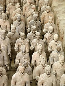
Pit 1
Pit 1, which is 230 metres (750 ft) long and 62 metres (203 ft) wide,[26] contains the main army of more than 6,000 figures.[27] Pit 1 has eleven corridors, most more than 3 metres (10 ft) wide and paved with small bricks with a wooden ceiling supported by large beams and posts. This design was also used for the tombs of nobles and would have resembled palace hallways when built. The wooden ceilings were covered with reed mats and layers of clay for waterproofing, and then mounded with more soil raising them about 2 to 3 metres (6 ft 7 in to 9 ft 10 in) above the surrounding ground level when completed.[28]Others
Pit 2 has cavalry and infantry units as well as war chariots and is thought to represent a military guard. Pit 3 is the command post, with high-ranking officers and a war chariot. Pit 4 is empty, perhaps left unfinished by its builders.Some of the figures in Pits 1 and 2 show fire damage, while remains of burnt ceiling rafters have also been found.[29] These, together with the missing weapons, have been taken as evidence of the reported looting by Xiang Yu and the subsequent burning of the site, which is thought to have caused the roof to collapse and crush the army figures below. The terracotta figures currently on display have been restored from the fragments.
Other pits that formed the necropolis also have been excavated.[30] These pits lie within and outside the walls surrounding the tomb mound. They variously contain bronze carriages, terracotta figures of entertainers such as acrobats and strongmen, officials, stone armour suits, burials sites of horses, rare animals and labourers, as well as bronze cranes and ducks set in an underground park.[31]
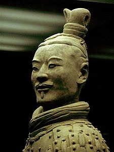
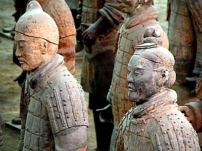
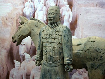
Warrior figures

A terracotta soldier with his horse
Types and appearance
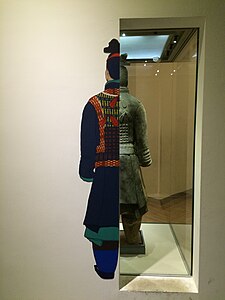
The terracotta figures are life-sized. They vary in height, uniform, and hairstyle in accordance with rank. Their faces appear to be different for each individual figure; scholars, however, have identified 10 basic face shapes.[32] The figures are of these general types: armored warriors; unarmored infantrymen; cavalrymen who wear a pillbox hat; helmeted drivers of chariots with more armor protection; spear-carrying charioteers; kneeling archers who are armored; standing archers who are not; as well as generals and other lower-ranking officers.[33] There are, however, many variations in the uniforms within the ranks: for example, some may wear shin pads while others not; they may wear either long or short trousers, some of which may be padded; and their body armors vary depending on rank, function, and position in formation.[34] There are also terracotta horses placed among the warrior figures.
Recreated figures of an archer and an officer, showing how they would have looked when painted
Some scholars have speculated a possible Hellenistic link to these sculptures, because of the lack of life-sized and realistic sculptures before the Qin dynasty.[37][38] They argued that potential Greek influence is particularly evident in some terracotta figures such as those of acrobats, as well as the technique used for casting bronze sculptures.[39][40] However, this idea is disputed by scholars and it has been pointed out that there is "no substantial evidence at all" for contact between ancient Greeks and Chinese builders of the tomb.[41] It is argued that such speculations in its core rest on flawed and old "Eurocentric" ideas that assumed other civilizations were incapable of sophisticated artistry and thus foreign artistry must be seen through western traditions.[41]
Construction
The terracotta army figures were manufactured in workshops by government laborers and local craftsmen using local materials. Heads, arms, legs, and torsos were created separately and then assembled by luting the pieces together. When completed, the terracotta figures were placed in the pits in precise military formation according to rank and duty.[42]The faces were created using molds, and at least ten face molds may have been used.[32] Clay was then added after assembly to provide individual facial features to make each figure appear different.[43] It is believed that the warriors' legs were made in much the same way that terracotta drainage pipes were manufactured at the time. This would classify the process as assembly line production, with specific parts manufactured and assembled after being fired, as opposed to crafting one solid piece and subsequently firing it. In those times of tight imperial control, each workshop was required to inscribe its name on items produced to ensure quality control. This has aided modern historians in verifying which workshops were commandeered to make tiles and other mundane items for the terracotta army.
Weaponry

Bronze jian sword with chrome plating


Stone armor suit on display in the National Geographic Museum.
An important element of the army is the chariot, of which four types have been found. In battle the fighting chariots formed pairs at the head of a unit of infantry. The principal weapon of the charioteers was the ge or dagger-axe, an L-shaped bronze blade mounted on a long shaft and used for sweeping and hooking at the enemy. Infantrymen also carried ge on shorter shafts, ji or halberds and spears and lances. For close fighting and defence, both charioteers and infantrymen carried double-edged straight swords. The archers carried crossbows, which have sophisticated trigger mechanisms and are capable of shooting arrows farther than 800 metres (2,600 ft).[51]
Scientific research
In 2007, scientists at Stanford University and the Advanced Light Source facility in Berkeley, California reported that powder diffraction experiments combined with energy-dispersive X-ray spectroscopy and micro-X-ray fluorescence analysis showed that the process of producing terracotta figures colored with Chinese purple dye consisting of barium copper silicate was derived from the knowledge gained by Taoist alchemists in their attempts to synthesize jade ornaments.[52][53]Since 2006, an international team of researchers at the UCL Institute of Archaeology have been using analytical chemistry techniques to uncover more details about the production techniques employed in the creation of the Terracotta Army. Using X-ray fluorescence spectrometry of 40,000 bronze arrowheads bundled in groups of 100, the researchers reported that the arrowheads within a single bundle formed a relatively tight cluster that was different from other bundles. In addition, the presence or absence of metal impurities was consistent within bundles. Based on the arrows’ chemical compositions, the researchers concluded that a cellular manufacturing system similar to the one used in a modern Toyota factory, as opposed to a continuous assembly line in the early days of the automobile industry, was employed.[54][55]
Grinding and polishing marks visible under a scanning electron microscope provide evidence for the earliest industrial use of lathes for polishing.[54]
Exhibitions

Terracotta Warriors exhibition in San Francisco, U.S.
Warriors and other artifacts were exhibited to the public at the Forum de Barcelona in Barcelona between 9 May and 26 September 2004. It was their most successful exhibition ever.[61] The same exhibition was presented at the Fundación Canal de Isabel II in Madrid between October 2004 and January 2005, their most successful ever.[62] From December 2009 to May 2010, the exhibition was shown in the Centro Cultural La Moneda in Santiago de Chile.[63]
The exhibition traveled to North America and visited museums such as the Asian Art Museum of San Francisco, Bowers Museum in Santa Ana, California, Houston Museum of Natural Science, High Museum of Art in Atlanta,[64] National Geographic Society Museum in Washington, D.C. and the Royal Ontario Museum in Toronto.[65] Subsequently, the exhibition traveled to Sweden and was hosted in the Museum of Far Eastern Antiquities between 28 August 2010 and 20 January 2011.[66][67] An exhibition entitled 'The First Emperor – China's Entombed Warriors', presenting 120 artifacts was hosted at the Art Gallery of New South Wales, between 2 December 2010 and 13 March 2011.[68] An exhibition entitled "L'Empereur guerrier de Chine et son armée de terre cuite" ("The Warrior-Emperor of China and his terracotta army"), featuring artifacts including statues from the mausoleum, was hosted by the Montreal Museum of Fine Arts from 11 February 2011 to 26 June 2011.[69] In Italy, from July 2008 to 16 November 2008, five of the warriors of the terracotta army were displayed in Turin at the Museum of Antiquities,[70] and from 16 April 2010 to 5 September 2010 were exposed nine warriors in Milan, at the Royal Palace, at the exhibition entitled "The Two Empires".[71] The group consisted of a horse, a counselor, an archer and 6 Lancers. The "Treasures of Ancient China" exhibition, showcasing two terracotta soldiers and other artifacts, including the Longmen Grottoes Buddhist statues, was held between 19 February 2011 and 7 November 2011 in four locations in India: National Museum of New Delhi, Prince of Wales Museum in Mumbai, Salar Jung Museum in Hyderabad and National Library of India in Kolkata.[citation needed]
Soldiers and related items were on display from 15 March 2013 to 17 November 2013, at the Historical Museum of Bern.[72]
Several Terracotta Army figures were on display, along with many other objects, in an exhibit entitled "Age of Empires: Chinese Art of the Qin and Han Dynasties" at The Metropolitan Museum of Art in New York City from 3 April 2017, to 16 July 2017.[73][74][75] An exhibition featuring ten Terracotta Army figures and other artifacts, "Terracotta Warriors of the First Emperor," was on display at the Pacific Science Center in Seattle, Washington, from 8 April 2017 to 4 September 2017[76][77] before traveling to The Franklin Institute in Philadelphia, Pennsylvania, to be exhibited from 30 September 2017 to 4 March 2018 with the addition of augmented reality.[78][79]
An exhibition entitled "China's First Emperor and the Terracotta Warriors" is at the World Museum in Liverpool from 9 February 2018 to 28 October 2018.[80] This is the first time in more than 10 years that the warriors have travelled to the UK.
Gallery
-
 A rank of soldiers
 -
 Close-up on the head of an archer
 -
 The face of each soldier differs and is constructed to be unique.
 -
 A cavalryman and his mount
 -
 Ranks of terracotta infantrymen
 -
 The Terracotta Warriors were once painted. Today only a handful of statues contain small amounts of paint. Also notice the detail put into the soles of the warrior's shoes.
 -
 Bronze chariot for the emperor
 -
 Terracotta horse and two soldiers
 -
 Close-up of an archer's head showing hair details and accessories
 -
 Pigments used on the Terracotta Warriors
 -
 Original coloring on the warriors
 -
 Original coloring on the warriors


List of time periods
This article has multiple issues. Please help improve it or discuss these issues on the talk page. (Learn how and when to remove these template messages)
|
Contents
Human Time Periods
These can be divided broadly into prehistorical (before history began to be recorded) and historical periods (when written records began to be kept).In archaeology and anthropology, prehistory is subdivided around the three-age system. This list includes the use of the three-age system as well as a number of various designation used in reference to sub-ages within the traditional three.
The dates for each age can vary by region. On the geologic time scale, the Holocene epoch starts at the end of the last glacial period of the current ice age (c.10,000 BC) and continues to the present. The beginning of Mesolithic is usually considered to correspond to the beginning of the Holocene epoch.
General Periods
- Prehistory – Period between the appearance of Homo ("humans"; first stone tools c. three million years ago) and the invention of writing systems (for the Ancient Near East: c. five thousand years ago).
- Stone Age
- Paleolithic – is the earliest period of the Stone Age
- Lower Paleolithic — time of archaic human species, predates Homo sapiens
- Middle Paleolithic — coexistence of archaic and anatomically modern human species
- Upper Paleolithic — worldwide expansion of anatomically modern humans, disappearance of archaic humans by extinction or admixture with modern humans; earliest evidence for pictorial art.
- Mesolithic (Epipaleolithic) – was a period in the development of human technology between the Palaeolithic and Neolithic periods.
- Neolithic – a period of primitive technological and social development, beginning about 10,200 BC in parts of the Middle East, and later in other parts of the world.
- Chalcolithic (or "Eneolithic", "Copper Age") – this period was still largely Neolithic in character, where early copper metallurgy appeared alongside the use of stone tools.
- Paleolithic – is the earliest period of the Stone Age
- Bronze Age – is not part of prehistory for all regions and civilizations who had adopted or developed a writing system.
- Iron Age – is not part of prehistory for all civilizations who had introduced written records during the Bronze Age.
- Stone Age
- Protohistory – Period between prehistory and history, during which a culture or civilization has not yet developed writing but other cultures have already noted its existence in their own writings; the absolute time scale of "protohistory" varies widely depending on the region, from the late 4th millennium BCE in the Ancient Near East to the present in the case of uncontacted peoples.
- Ancient history
– Aggregate of past events from the beginning of recorded human history
and extending as far as the Early Middle Ages or the Postclassical Era.
The span of recorded history is roughly less than five thousand years, beginning with the earliest linguistic records in the third millennium BC in Mesopotamia and Egypt.
- Classical antiquity – Broad term for a long period of cultural history centered on the Mediterranean Sea, comprising the interlocking civilizations of ancient Greece and ancient Rome, collectively known as the Greco-Roman world. It is the period in which Greek and Roman society flourished and wielded great influence throughout Europe, North Africa and the Middle East.
- Post-classical history
– Period of time that immediately followed ancient history. Depending
on the continent, the era generally falls between the years CE 200–600
and CE 1200–1500. The major classical civilizations the era follows are Han China (ending in 220), the Western Roman Empire (in 476), the Gupta Empire (in the 550s), and the Sasanian Empire (in 651).
- Middle Ages (also called Dark Ages) – Lasted from the 5th to the 14th century. It began with the collapse of the Western Roman Empire in 476 and is variously demarcated by historians as ending with the Fall of Constantinople in 1453, merging into the Renaissance and the Age of Discovery.
- Modern history – After the post-classical era
- Early modern period – The chronological limits of this period are open to debate. It emerges from the Late Middle Ages (c. 1500), demarcated by historians as beginning with the Fall of Constantinople in 1453, in forms such as the Italian Renaissance in the West, the Ming Dynasty in the East, and the rise of the Aztec in the New World. The period ends with the beginning of the Age of Revolutions.
- Late modern period – Began approximately in the mid-18th century; notable historical milestones included the French Revolution, the American Revolution, the Industrial Revolution and the Great Divergence.
- Machine Age (1880–1945)
- Age of Oil (1901–present)
- World War I (1914–1918)
- Interwar period (1918–1939)
- Roaring Twenties (1920–1929)
- Great Depression (1929–1939)
- World War II (1939–1945)
- Machine Age (1880–1945)
- Contemporary history
– History within living memory. It shifts forward with the generations,
and today is the span of historic events from approximately 1945 that
are immediately relevant to the present time. For example, the Post-Modern movement (Soviet Union and United States, 1973–present)
- Socio Cultural Periods
- The Forties (1940–1949)
- The Fifties (1950–1959)
- The Sixties (1960–1969)
- The Seventies (1970–1979)
- The Eighties (1980–1989)
- The Nineties (1990–1999)
- The Two Thousands (2000–2009)
- The Tens (2010–2019)
- The Twenties (2020-2029)
- Technology Periods
- Jet Age (1940s)
- Atomic Age (1945–present)
- The Nuclear Age (1950–present) [2]
- Digital Revolution (1950s–present)
- Space Age (1957–present)
- Information Age (1970–present)
- The Multimedia Age (1987–present)
- The Social Age (1996–present)
- The Big Data age (2001–present)[3]
- Contemporary Wars
- Post-war era (1946–1962)
- Cold War (Soviet Union and United States, and their allies, 1945–1991)
- Korean War (1950–1953)
- Vietnam War (1955–1975)
- Cold War (Soviet Union and United States, and their allies, 1945–1991)
- Bosnian War (1992–1995)
- War on Terrorism (2001–present)
- War in Afghanistan (2001–2014)
- War in Iraq (2003–2011)
- Post-war era (1946–1962)
- Socio Cultural Periods
America Periods
- Classic and Postclassic eras, Central America (200–1519)
- Early Intermediate, Middle Horizon, Late Intermediate, Late Horizon (Peru, 200–1534)
- Baroque (New World, 1600–1750)
- Spanish hegemony (Americas, 16th century – 1820s)
- Reconstruction era (United States, 1865–1877)
- Gilded Age (United States, 1875–1900)
- Progressive Era (United States, 1890s–1920s)
- Information Age (United States, 1970–present)
Southeast Asia Periods
- Srivijaya (Indonesia, 3rd – 14th centuries), Tarumanagara (358–723), Sailendra (8th and 9th centuries), Kingdom of Sunda (669–1579), Kingdom of Mataram (752–1045), Kediri (1045–1221), Singhasari (1222–1292), Majapahit (1293–1500)
- Chenla (Cambodia, 630 – 802) and Khmer Empire (Cambodia, 802–1432)
- Anterior Lý Dynasty and Triệu Việt Vương, Third Chinese domination, Khúc Family, Dương Đình Nghệ, Kiều Công Tiễn, Ngô Dynasty, The 12 Lords Rebellion, Đinh Dynasty, Prior Lê Dynasty, Lý Dynasty, Trần Dynasty, Hồ Dynasty, Fourth Chinese domination (Vietnam, 544–1427)
Philippines Periods
- Neolithic-Iron Age (c.10,000 BC – AD 900)
- Archaic period (AD 900–1521)
- Spanish Colonial Period (1521–1898)
- American Colonial Period (1898–1946)
- Sovereign Era (1946–present)
- Marcos era Martial Law (1972–1982)
- People power EDSA revolution (1986)
- Post Martial Law (1986–present)
China Periods
- Three Sovereigns and Five Emperors (2852–2070 BCE)
- Xia dynasty (2070–1600 BCE)
- Shang dynasty (1600–1046 BCE)
- Zhou dynasty (1046–221 BCE)
- Western Zhou (1046–771 BCE)
- Eastern Zhou (771–221 BCE)
- Spring and Autumn period (771–476 BCE)
- Warring States period (476–221 BCE)
- Qin Dynasty (221–206 BCE)
- Han Dynasty (206 BCE – 220 CE)
- Western Han (206 BCE – 2 CE)
- Xin dynasty (9–23 CE)
- Eastern Han (25–220 CE)
- Six Dynasties (220–580)
- Three Kingdoms (220–265)
- Jin Dynasty (265–420)
- Southern and Northern Dynasties (420–580)
- Sui Dynasty (580–618)
- Tang Dynasty (623–907)
- Five Dynasties and Ten Kingdoms period (907–960)
- Song Dynasty (960–1279)
- Northern Song (960–1127), Liao Dynasty (907–1115)
- Western Xia dynasty (1038–1227)
- Southern Song (1127–1279), Jin dynasty (1115–1234)
- Yuan Dynasty (1271–1368)
- Ming Dynasty (1368–1644)
- Qing Dynasty (1644–1911)
- Republic of China (1912–1949)
- Xinhai Revolution (1911–1912)
- Warlord Era (1918–1927)
- Chinese Civil War (1927-1936/1946-1950)
- Second Sino-Japanese War (1931–1945)
- People's Republic of China (1949–present)
Central Asia Periods
- Xiongnu (Mongolia, 220 BC – AD 200)
- Rouran Khaganate (Mongolia, Manchuria, Xianbei, AD 330 – 555)
- Sixteen Kingdoms (Xianbei, Turkic peoples, 304 – 439)
- Uyghur Khaganate (Mongolia, Manchuria, Tibet, 744 – 848)
- Liao Dynasty (Khitan people, 907 – 1125)
- Mongol Empire (Mongolia, 1206 – 1380)
- Qing dynasty (Manchu China, 1692 – 1911)
Egypt Periods
Template:No information on rest of Africa- Old Kingdom (3000 BC – 2000 BC)
- Middle Kingdom (2000 BC – 1300 BC)
- New Kingdom (1550 BC – 1070 BC)
- Ptolemaic Kingdom (305 BC – 30 BC)
- Aegyptus (30 BC – 390 AD)
- Coptic period (300 AD – 900 AD)
- Fatimid Caliphate (909–1171)
- Ayyubid Dynasty (1171–1250)
- Mamluk Sultanate (1250–1517)
- Ottoman Eyalet (1517–1867)
- Khedivate (1867–1914)
Europe Periods
- Bronze Age (c.3000 BC – c.1050 BC)
- Iron Age (c.1050 BC – c.500 AD)
- Greek expansion and colonisation (c.1050 BC – 776 BC)
- Archaic Greece (776 BC – 480 BC) – begins with the First Olympiad, traditionally dated 776 BC
- Archaic period (776 BC – 612 BC) – establishment of city states in Greece
- Pre-classical period (612 BC – 480 BC) – the fall of Nineveh to the second Persian invasion of Greece
- Classical antiquity (480 BC – 476 AD)
- Classical Greece (480 BC – 399 BC)
- Macedonian era (399 BC – 323 BC)
- Hellenistic Greece (323 BC – 146 BC)
- Late Roman Republic (147 BC – 27 BC)
- Principate of the Roman Empire (27 BC – 284 AD)
- Late Antiquity (284 AD – 500 AD)
- Migration Period (Europe, 300 AD – 700 AD)
- Middle Ages (Europe, 476 – 1453)
- Byzantine era (330–1453)
- Early Middle Ages (Europe, 476 – 1066)
- Dark Ages (Europe, 476 – 800)
- Viking Age (Scandinavia, Europe, 793 – 1066)
- High Middle Ages (Europe, 1066 – c.1300)
- Late Middle Ages (Europe, c.1300 – 1453)
- The Renaissance (Europe, c.1300 – c.1600)
- Early modern period (Europe, 1453 – 1789)
- Age of Discovery (or Exploration) (Europe, c.1400 – 1770)
- Polish Golden Age (Poland, 1507 – 1572)
- Golden Age of Piracy 1650 – 1730
- Elizabethan era (United Kingdom, 1558 – 1603)
- Protestant Reformation (Europe, 16th century)
- Classicism (Europe, 16th – 18th centuries)
- Industrious Revolution, (Europe, 16th – 18th centuries)
- Jacobean era (United Kingdom, 1603 – 1625)
- Petrine Era (Russia, 1689 – 1725)
- Age of Enlightenment (or Reason) (Europe, 18th century)
- Long nineteenth century (1789–1914)
- Georgian era (United Kingdom, 1714 – 1830)
- Industrial Revolution (Europe, United States, elsewhere 18th and 19th centuries)
- Age of European colonialism and imperialism
- Romantic era (1770–1850)
- Napoleonic era (1799–1815)
- Victorian era (United Kingdom, 1837 – 1901); British hegemony (1815-1914) much of world, around the same time period.
- Edwardian era (United Kingdom, 1901 – 1914)
- First and Second World Wars (1914–1945)
- Cold War (1945–1991)
- Post-Cold War / Postmodernity (1991 – present)
India Periods
- Indus Valley Civilization (2500 BC – 1300 BC)
- Vedic period (1500 BC – 500 BC)
- Mahajanapada kingdoms
- Maurya Empire (321 BC – 185 BC)
- Kushan Empire (185 BC – 220 AD), Satavahana Empire (230 BC – 220 AD),
- Gupta Empire (320 AD – 535 AD)
- Vakatak Empire (300AD −650 AD)
- Middle kingdoms of India (1 AD – 1279 AD)
- Pala Empire (750–1174)
- Sena Empire (1070–1230)
- Hoysala Empire (1026 –1343), Kakatiya Empire (1083–1323)
- Medieval India (1206–1526)
- Vijayanagara Empire (1336–1646), Gajapati Kingdom (1434–1541), Reddy dynasty (1325–1448)
- Mughal Empire (1526–1857)
- Maratha Empire (1674–1818)
- British Raj (1858–1947)
- Independence (1947–present)
Japan Periods
- Jōmon period (10,501 BC – 400 BC)
- Yayoi period (450 BC – 250 AD)
- Kofun period (250–600)
- Asuka period (643–710)
- Nara period (743–794)
- Heian period (795–1185)
- Kamakura period (1185–1333)
- Muromachi period (1333–1573)[5]
- Azuchi–Momoyama period (1573–1603)
- Tokugawa shogunate (1603–1868)
- Meiji period (1868–1912)
- Taishō period (1912–1926)
- Shōwa period (1945–1989)
- Post-occupation era (1952 – present)
- Heisei period (1989–present)
Middle East Periods
- Ancient Near East (Sumer, 3100 BC – 500 BC)
- Jemdet Nasr period (3100 BC – 2900 BC)
- Early Dynastic Period (2900 BC – 2270 BC)
- Akkadian Empire (2270 BC – 2083 BC)
- Gutian Dynasty (2083 BC – 2050 BC)
- Sumerian renaissance (2050 BC – 1940 BC)
- First Babylonian Dynasty (1830 BC – 1531 BC), Hittites (1800 BC – 1178 BC)
- Kassites (1531 BC – 1135 BC), Mitanni (1500 BC – 1300 BC)
- Neo-Assyrian Empire (934 BC – 609 BC)
- Neo-Babylonian Empire (626 BC – 539 BC), Medes (678 BC – 549 BC)
- Persian Empires (550 BC – 651 AD)
- Achaemenid Empire (550 BC – 330 BC)
- Conquered by Macedonian Empire (330 BC – 312 BC)
- Seleucid Empire (312 BC – 63 BC)
- Parthian Empire (247 BC – 224 AD)
- Sasanian Empire (224 AD – 651 AD)
- Islamicate periods[6] (7th – 21st centuries[citation needed])
- High Caliphate (685–945)[7]
- Earlier Middle Period (945–1250)[6]
- Later Middle Period (1250–1500)[6]
- Islamic Golden Age (c. 8th–13th century)
- Rashidun Caliphate (632–661)
- Umayyad Caliphate (661–750)
- Abbasid Caliphate (750–1258), Fatimid Caliphate (909–1171)
- Buyid dynasty (934–1055)
- Seljuq dynasty (1055–1171)
- Ayyubid dynasty (1171–1341)
- Ottoman Empire (1300–1923), Safavid Empire (1501–1736)
Mythological and astrological time periods
- Astrological ages
- Greek mythology (See also: Ages of Man)
- Golden Age, self-sufficient
- Silver Age, self-indulgent
- Bronze Age, warlike
- Heroic Age, nobly aspirant
- Iron Age, violent
- Aztec mythology
- Nahui-Ocelotl, Destroyed by Jaguars
- Nahui-Ehécatl, Destroyed by Hurricane
- Nahuiquiahuitl, Destroyed by rain of Fire
- Nahui-Atl, Destroyed by Flood
- Nahui-Ollin, Destroyed by Earthquakes
Marxian stages of history
The Marxian theory of history identifies five major distinct periods of history:[8][9][10][11][12]Primitive communism
The First Stage: is usually called primitive communism. It has the following characteristics.- Shared property: there is no concept of ownership beyond individual possessions. All is shared by the tribe to ensure its survival.[citation needed]
- Hunting and gathering: tribal societies have yet to develop large scale agriculture and so their survival is a daily struggle.[citation needed]
- Proto-democracy: there is usually no concept of "leadership" yet. So tribes are led by the best warrior if there is war, the best diplomat if they have steady contact with other tribes and so forth.
Slave society
The Second Stage: may be called slave society, considered to be the beginning of "class society" where private property appears.- Class: here the idea of class appears. There is always a slave-owning ruling class and the slaves themselves.
- Statism: the state develops during this stage as a tool for the slave-owners to use and control the slaves.
- Agriculture: people learn to cultivate plants and animals on a large enough scale to support large populations.
- Democracy and authoritarianism: these opposites develop at the same stage. Democracy arises first with the development of the republican city-state, followed by the totalitarian empire.
- Private property: citizens now own more than personal property. Land ownership is especially important during a time of agricultural development.
Feudalism
The Third Stage: may be called feudalism; it appears after slave society collapses. This was most obvious during the European Middle Ages when society went from slavery to feudalism.- Aristocracy: the state is ruled by monarchs who inherit their positions, or at times marry or conquer their ways into leadership.
- Theocracy: this is a time of largely religious rule. When there is only one religion in the land and its organizations affect all parts of daily life.
- Hereditary classes: castes can sometimes form and one's class is determined at birth with no form of advancement. This was the case with India.
- Nation-state: nations are formed from the remnants of the fallen empires. Sometimes, they rebuild themselves into empires once more; this was the case with England's transition from a province to an empire.
Capitalism
Capitalism may be considered the Fourth Stage in the sequence. Marx pays special attention to this stage in human development. The bulk of his work is devoted to analysing the mechanisms of capitalism, which in western society classically arose "red in tooth and claw" from feudal society in a revolutionary movement. In capitalism, the profit motive rules and people, freed from serfdom, work for the capitalists for wages. The capitalist class are free to spread their laissez faire practices around the world. In the capitalist-controlled parliament, laws are made to protect wealth.Capitalism appears after the bourgeois revolution when the capitalists (or their merchant predecessors) overthrow the feudal system, and it is categorized by the following:
- Market economy: In capitalism, the entire economy is guided by market forces. Supporters of laissez-faire economics argue that there should be little or no intervention from the government under capitalism. Marxists, however, such as Lenin in his Imperialism, the Highest Stage of Capitalism, argue that the capitalist government is a powerful instrument for the furtherance of capitalism and the capitalist nation-state, particularly in the conquest of markets abroad.
- Private property: The means of production are no longer in the hands of the monarchy and its nobles, but rather they are controlled by the capitalists. The capitalists control the means of production through commercial enterprises (such as corporations) which aim to maximise profit.
- Parliamentary democracy: The capitalists tend to govern through an elected centralised parliament or congress, rather than under an autocracy. Capitalist (bourgeois) democracy, although it may be extended to the whole population, does not necessarily lead to universal suffrage. Historically it has excluded (by force, segregation, legislation or other means) sections of the population such as women, slaves, ex-slaves, people of colour or those on low income. The government acts on behalf of, and is controlled by, the capitalists through various methods.
- Wages: In capitalism, workers are rewarded according to their contract with their employer. Power elites propagate the illusion that market forces mean wages converge to an equilibrium at which workers are paid for precisely the value of their services. In reality workers are paid less than the value of their productivity — the difference forming profit for the employer. In this sense all paid employment is exploitation and the worker is "alienated" from their work. Insofar as the profit-motive drives the market, it is impossible for workers to be paid for the full value of their labour, as all employers will act in the same manner.
- Imperialism: Wealthy countries seek to dominate poorer countries in order to gain access to raw materials and to provide captive markets for finished products. This is done directly through war, the threat of war, or the export of capital. The capitalist's control over the state can play an essential part in the development of capitalism, to the extent the state directs warfare and other foreign intervention.
- Financial institutions: Banks and capital markets such as stock exchanges direct unused capital to where it is needed. They reduce barriers to entry in all markets, especially to the poor; it is in this way that banks dramatically improve class mobility.
- Monopolistic tendencies: The natural, unrestrained market forces will create monopolies from the most successful commercial entities.
Socialism
After the working class gains class consciousness and mounts a revolution against the capitalists, socialism, which may be considered the Fifth Stage, will be attained, if the workers are successful. Marxist socialism may be characterised as follows:- Common property: the means of production are taken from the hands of a few capitalists and put in the hands of the workers. This translates into the democratic communes controlling the means of production.
- Council democracy: Marx, basing himself on a thorough study of Paris Commune, believed that the workers would govern themselves through system of communes. He called this the dictatorship of the proletariat, which, overthrowing the dictatorship (governance) of capital, would democratically plan production and the resources of the planet.
Geologic time periods
The geologic time scale covers the extent of the existence of Earth, from about 4600 million years ago to the present day. It is marked by Global Boundary Stratotype Sections and Points. Geologic time units are (in order of descending specificity) eons, eras, periods, epochs, and ages; and the corresponding chronostratigraphic units, which measure "rock-time", are eonothems, erathems, systems, series, and stages.The second and third timelines are each subsections of their preceding timeline as indicated by asterisks. The Cenozoic is sometimes divided into the Quaternary and Tertiary periods, although the latter is no longer used officially.
Cosmological time periods
13.8 billion years ago: The Big Bang Theory (the universe's beginnings)
| Time Period | Duration | Description |
|---|---|---|
| Planck epoch | From the start to 10−43 seconds after the Big Bang | Very little concrete information is known about this epoch. Different theories propose different views on this particular time. |
| Grand unification epoch | Between 10−43 to 10−36 seconds after the Big Bang | The result of the universe expanding and cooling down during the Planck epoch. All fundamental forces except gravity are unified. |
| Electroweak epoch | Between 10−36 seconds to 10−12 seconds after the Big Bang | The universe cools down to 1028 kelvin. The fundamental forces are split into the strong force and the electroweak force. |
| Inflationary epoch | Between 10−36 seconds to 10−32 seconds after the Big Bang | The shape of the universe flattens due to cosmic inflation. |
| Quark epoch | Between 10−12 seconds to 10−6 seconds after the Big Bang | Cosmic inflation has ended. Quarks are present in the universe at this point. The electroweak force is divided again into the weak force and electromagnetic force. |
| Hadron epoch | Between 10−6 seconds to 1 second after the Big Bang | The universe has cooled enough for quarks to form hadrons, protons, neutrons. |
| Lepton epoch | Between 1 second to 10 seconds after the Big Bang | Most hadrons and anti-hadrons annihilate each other, leaving behind leptons and anti-leptons. |
| Photon epoch | Between 10 seconds to 370,000 years after the Big Bang | Most leptons and anti-leptons annihilate each other. The universe is dominated by photons. |
| Nucleosynthesis | Between 3 minutes to 20 minutes after the Big Bang | The temperature of the universe has cooled down enough to allow atomic nuclei to form via nuclear fusion. |
| Recombination | About 377,000 years after the Big Bang | Hydrogen and helium atoms form. |
| Reionization | Between 150 million and 1 billion years after the Big Bang | The first stars and quasars form due to gravitational collapse. |
See also
- Logarithmic timeline shows all history on one page in ten lines.
- Periodization for a discussion of the tendency to try to fit history into non-overlapping periods.
- List of fossil sites with link directory.
- List of timelines around the world.


No comments:
Post a Comment