Presents, a Life with a Plan. My name is Karen Anastasia Placek, I am the author of this Google Blog. This is the story of my journey, a quest to understanding more than myself. The title of my first blog delivered more than a million views!! The title is its work as "The Secret of the Universe is Choice!; know decision" will be the next global slogan. Placed on T-shirts, Jackets, Sweatshirts, it really doesn't matter, 'cause a picture with my slogan is worth more than a thousand words, it's worth??.......Know Conversation!!!
The Amount of Pain on my head[Head] is not word answered[Answered] by word swallowing[Swallowing]!! Word this[This] did not equated word answer[Answer] as word these are tools!! Mayor Jerry Dyer see ][Police Chief Jerry Dyer introduces new Real Time Crime Center]]
c.[see]: Word[word] name called[Called] Tamara gave word I a horse named word Beau and word said horse was word at[@] UC Davis in Templeton? No UC Davis is in California the state of? No. UC Davis is a word Vet school[School] in word named town[Town] Davis.
14. Is word equated word difficult[Difficult] as on KRON4 local word media[Media[San Francisco, California]] word reported a motorcycle type wheel with the engine in word well. That word well equated word light and word flute for word Earth so the magma of steam equated word well[volcano[Volcano]:
A.
You searched for
"DIFFICULT" in the KJV Bible
goog_1153684825
No Results. No direct matches for your keyword(s) were found in King James Bible text, however, please consider one of the following actions:
1. If unsure of spelling, try searching only one word at a time. 2. Try changing your keyword(s). 3. Try modifying and expanding your search. 4. Try the related matches on the right-side of the page (or below). 5. Try the search options below: Smart Search (if available) or Search Everything (including web pages in addition to the KJV text).
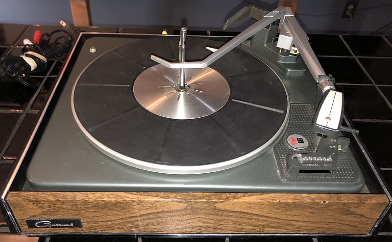
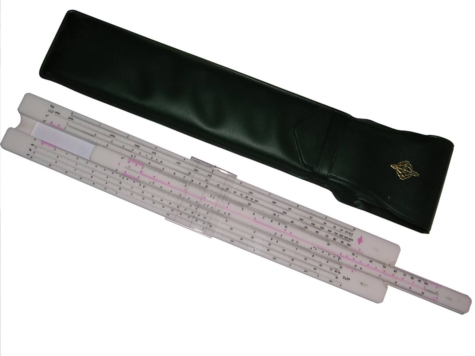
This Slide rule[picture of[Picture of]] word represents word applicable[Slide Rule MEN] as word SLIDE RULES are able word now[NOW] to go word either directions however is word still looks like a belt buckle!!
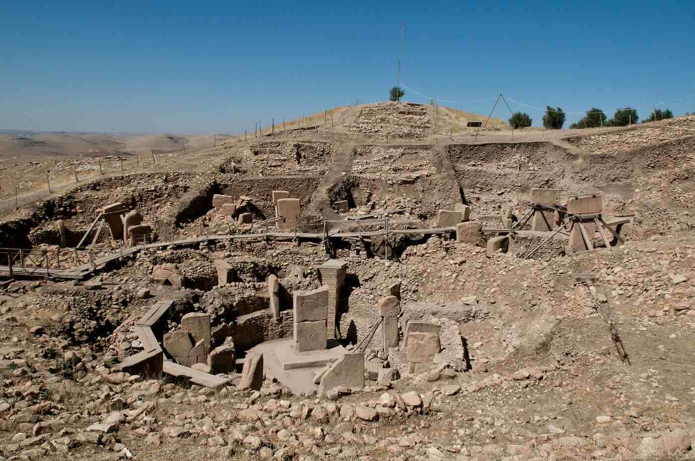
Cantore Arithmetic is able to state words explanation as word Göbekli Tepe equated words. For all the Doctors albeit word taped[difficult] word their.
Words somebody built Göbekli Tepe and it word serves[Serves] word dynamic[s], a stethoscope to words your hands!!
Word Dorchester happened at words numbered 815 Balboa, a word Street[state[State]] equated word in words the City of word town[San Francisco!!]. Words While I was sleeping a word bundle wrapped my head[brain[white]] and words applicable[Louise Rodgers] stated in word voice the next day without word reservation and after word inspecting word these strange marks stated with a strange word environment those are stretch marks!!
To state word weird as word typing is word difficult[hard] and word yet is word important[insult]. So word applicable[patience] is word sufficient. Words while I was sleeping did not suffice my ever standing word issue that word I understood. Louise Rodgers is not word someone I understood however word understood in words strange voice[equate vernacular here *] only the word capacitor of those marks.
Göbekli Tepe is dust. And, yet you[Doctors[PhD] are word fathomed to word it.
1. There is a hammer and that hammer banged like Thumpers foot in Bambi[Film]: Bambi(1942) - Bambi Meets Thumper: https://www.youtube.com/watch?v=Fk3k4s1zXOI word Youtube equated word counter[Counter!!] Youtube equated word count[blood
A primary computing tool for engineers, used until electronic pocket calculators became popular in 1980s. Simple logarithmic one-scale grid was invented around 1620 by E. Gunter, it's used even today for mapping and navigation purposes. In 1632 William Oughtred added secondary scale to make a simple rule. Additional scale enhancements were made by E. Wingate and S. Patridge. In today's form slide rule was invented by A. Manheim in 1850. In XX century Darmstadt introduced Log-Log scales, later Ritz added 3 trigonometric scales and inverted scale.
A typical linear slide rule consists of a set of scales, these scales are placed in moving part (a middle one) and outer part. Usually there's also a transparent moving part called cursor, with a vertical line which allows to point a number in a slider.
Logarex 27402-III Typical slide rule from 1970s, made in Czechoslovakia. It has all typical scales. Trigonometric scales are on the reverse of slider. In some scales you can see "Cu", "Al" and similar markings. These are for computing amount of power which can be drawn from a cable made of specific alloys. It was a good aid for power engineering appliances. It's made of white plastic, quite durable but it can get stuck if not handled properly, then it needs to be moved back and forth few times.
General view with cover
Cursor
Markings
Hemmi Bambou - Patent 58115 This Japanese slide rule was used by my Grandfather. It has all basic scales plus trigonometric on reverse of slider. It's made of bamboo wood, so it is self-lubricating and it still slides smoothly without jams. Cursor is made of metal and celluloid. It was manufactured between 1917 and 1927. But some other sources state that these cursors were used until 1930s. Hemmi, from Jiro Hemmi, was a well known brand in manufacturing these instruments. In 1910 they started manufacturing slide rules from bamboo wood, making it self-lubricating and preserving geometry. In 1912 Hemmi got a Japanese patent for a slide rule made of wood with laminated, celluloid scale. In 1917 they started to use Sun trademark for foreign market. In 1928 company changed its name to Hemmi Seisakusho & Co. Then they started labelling cursors "Sun Hemmi". In 1930s they manufactured thousands rules every year. Since 1928 some Hemmi rules have P and Q scales. Seen on a few photos, but I have no idea what they could be used for. As most Japanese companies, Hemmi's business disappeared with starting of world war II. Some small quantities were manufactured until 1950s (last ones even in 1970s), but it was not a big production. More: MANUAL, incomplete, and in strange format (photo of a museum item).
With cover
Cover detail
Cursor
Some conversion tables. Notice Polish "Gerlach", it's not cutlery manufacturer but Gustaw Gerlach - clockmaker.
Under the slider
Trigonometric scales
If you want to know Hemmi's history, I recommend visiting this page. If you want more history, you can take a look at archived copy of Japanese slide rules page. Nice timeline of Hemmi's business.
Pocket slide rule This small slide rule was used even in high schools as simple calculator. It's probably from 1960s of 70s.
With cover
2*9=...
[added: 2016-03-12] "SP" Soviet slide rule Soviet slide rule made in 1953. It is made of wood coated with celluloid, so it has good lubrication and doesn't get stuck. The pointer is made of metal with celluloid window. It was made in Leningrad (today Saint Petersburg), by "Factory of computing instruments", being a "Industrial division of Lengorispolkom", according to markings. Lengorispolkom is the executive comitee of Leningrad city. The rule has normal, trigonometrical and S-T scales (on the other side of slider). It has also a normal ruler for quick drawing and table of typical engineering constants on the reverse. The logo present on the box and rule is not known, probably it has some relations to "CCCP".
[added: 2016-03-12] Skala "SLPP" Slide Rule A Polish slide rule made in 1960s. It is made of plastic, so lubrication is not perfect and currently it doesn't move as slightly as wooden ones. It is quite long and has many scales in front, but no scales on the rear or slider's reverse. All scales are typical x, x^2 and 1/x scales, x^3, Square root, logarithmic, trigonometric (sin, tg, S-T) and special "M" scale for computing of lengths in right-angled triangle.
Typical scales are: - A and B (labelled X) logarithmic scales (1 - 10, sometimes labelled as "right 1"), placed one on slider one on outer part, used to divide and multiply numbers. - C and D logarithmic scales, 2-decade (labelled X2), one on slider, one on outer part. - G scale (1/X) located on slider - used to compute inversions - F (or L, Log) - linear scale for finding logarithms - E (or Ln) - ex scale for finding exponentials - LL scales - used to find logarithms and exponentials - S, T and ST trigonometric scales, located on sliding part (popular in eastern block rules) or outer.
If you compute using slide rule remember to get along with decimal places of the result!
Simple computations:
1. Multiplying: a*b = x a. Mark a on A scale using 1 of B-scale b. Read result from scale A under "b" on scale B. c. If there's a*b*c=y, mark temporary result with cursor, put B's 1 there, read result from A-scale under B's "c".
If you multiply by value smaller than 1, use "right 1" of the scale moving slider to the left. If you move slider to the left, remember that count of integer digits is reduced by count of zeros after "0," of this number! You can multiply with X2 scale, but it won't be as precise as in X. Picture on the right shows 32*5 multiplication using X2 scale.
2. Division: a/b=x a. Mark a on scale A with cursor. b. Move scale B to set b under cursor c. Read result from scale A under "1" (or "right 1" - if division by <1 used) of scale B.
3. Inversions - Inversion of number on scale B is a number on scale G. Simple. Or just divide 1/x.
4. Square: a^2=x a. Mark a on scale A with cursor b. Read square from scale D (under cursor)
5. Any power: ab=x a. Use ex scale, set 1 of "X" scale in a in ex scale. b. Find b on "X" scale, read result on ex scale under it.
Göbekli Tepe (Turkish:[ɟœbecˈliteˈpe],[2]'Potbelly Hill';[3]Kurdish: Girê Mirazan or Xerabreşkê, 'Wish Hill'[4]) is a Neolithicarchaeological site in Turkey, on the southern border of Southeastern Anatolia. The settlement was inhabited from around 9500 BCEto at least 8000 BCE,[5] during the Pre-Pottery Neolithic. It is famous for its large circular structures that contain massive stone pillars – among the world's oldest known megaliths. Many of these pillars are decorated with anthropomorphic details, clothing, and sculptural reliefs of wild animals, providing archaeologists rare insights into prehistoric religion and the particular iconography of the period. The 15 m (50 ft) high, 8 ha (20-acre) tell is densely covered with ancient domestic structures[6] and other small buildings, quarries, and stone-cut cisterns from the Neolithic, as well as some traces of activity from later periods.
The site was first used at the dawn of the southwest Asian Neolithic period, which marked the appearance of the oldest permanent human settlements anywhere in the world. Prehistorians link this Neolithic Revolution to the advent of agriculture, but disagree on whether farming caused people to settle down or vice versa. Göbekli Tepe, a monumental complex built on the top of a rocky mountaintop, with no clear evidence of agricultural cultivation, has played a prominent role in this debate.
Recent findings suggest that there was a settlement at Göbekli Tepe, with domestic structures, extensive processing of cereals, a water supply, and tools associated with daily life.[7] This contrasts to a previous interpretation of the site as a sanctuary used by nomads, with few or no permanent inhabitants.[1] No definitive purpose has been determined for the megalithic structures, which have been popularly described as the "world's first temple[s]".[8] They were likely roofed, and appear to have regularly collapsed, been inundated by slope slides, and subsequently repaired or rebuilt.[9] The architecture and iconography is similar to other contemporary sites in the vicinity, such as Karahan Tepe.[10]
The site was first noted in a survey in 1963. German archaeologist Klaus Schmidtrecognized its significance in 1994 and began excavations there the following year. After his death in 2014, work continued as a joint project of Istanbul University, Şanlıurfa Museum, and the German Archaeological Institute, under the direction of Turkish prehistorian Necmi Karul. Göbekli Tepe was designated a UNESCO World Heritage Sitein 2018, recognising its outstanding universal value as "one of the first manifestations of human-made monumental architecture".[11] As of 2015, less than 5% of the site had been excavated.[12] Additional areas were examined by geophysical surveys, which showed the mound to contain at least 20 large enclosures.[13]
Geography and environment
Present day landscape around Göbekli Tepe
Göbekli Tepe is located in the Taş Tepeler ('Stone Hills'), in the foothills of the Taurus Mountains.[14] It overlooks the Harran plain and the headwaters of the Balikh River, a tributary of the Euphrates.[14] The site is a tell (artificial mound) on a flat limestoneplateau.[15] In the north, the plateau is connected to the neighbouring mountains by a narrow promontory. In all other directions, the ridge descends steeply into slopes and steep cliffs.[16]
The climate of the area was warmer and wetter when Göbekli Tepe was occupied than it is today.[15] The site was surrounded by an open steppe grassland,[15] with abundant wild cereals, including einkorn, wheat, and barley,[17] and herds of grazing animals such as wild sheep, wild goat, gazelle, and equids.[18] Large herds of goitered gazelle may have passed by the site in seasonal migrations.[19] There is no evidence of substantial woodlands nearby;[15] 90% of the charcoal recovered at the site was from pistachio or almond trees.[20]
Like most Pre-Pottery Neolithic (PPN) sites in the Urfa region, Göbekli Tepe was built on a high point on the edge of the mountains, giving it both a wide view over the plain beneath, and good visibility from the plain.[21] This location also gave the builders good access to raw material: the soft limestone bedrock from which the complex was built, and the flint to make the tools to work the limestone.[21] The prehistoric village acquired drinking water through a rainwater harvestingsystem, consisting of carved channels[22] that fed several cisterns carved into the bedrock under the site,[23] which could hold at least 150 cubic metres (5,300 cu ft) of water.[24][25] Additionally, the local water table may have been higher, activating springs closer to the site which are dormant today.[26]
Excavations have taken place at the southern slope of the tell, south, and west of a mulberry that marks an Islamic pilgrimage,[27] but archaeological finds come from the entire plateau. The team has also found many remains of tools. At the western escarpment, a small cave has been discovered in which a small relief depicting a bovid was found. It is the only relief found in this cave.[28]
Dawn of village life
Göbekli Tepe was built and occupied during the earliest part of the Southwest Asian Neolithic, known as the Pre-Pottery Neolithic(PPN, c. 9600–7000 BCE).[29] Beginning at the end of the last Ice Age, the PPN marks "the beginnings of village life",[30] producing the earliest evidence for permanent human settlements in the world.[30][31] Archaeologists have long associated the appearance of these settlements with the Neolithic Revolution—the transition from hunting and gathering to agriculture—but disagree on whether the adoption of farming caused people to settle down, or settling down caused people to adopt farming.[32] Despite the name, the Neolithic Revolution in Southwest Asia was "drawn out and locally variable".[33] Elements of village life appeared as early as 10,000 years before the Neolithic in places,[34][35] and the transition to agriculture took thousands of years, with different paces and trajectories in different regions.[36][37] Archaeologists divide the Pre-Pottery Neolithic into two subperiods: the Pre-Pottery Neolithic A(PPNA, c. 9600–8800 BCE) and the Pre-Pottery Neolithic B (PPNB, c. 8800 and 7000 BCE).[31] The earliest phases at Göbekli Tepe have been dated to the PPNA; later phases to the PPNB.[38]
Evidence indicates the inhabitants of Göbekli Tepe were hunter-gatherers who supplemented their diet with early forms of domesticated cereal and lived in villages for at least part of the year. Tools such as grinding stones and mortars and pestles found at the site have been analyzed and suggest considerable cereal processing. Archaeozoological evidence hints at "large-scale hunting of gazelle between midsummer and autumn."[24]
PPN villages consisted mainly of clusters of stone or mud brick houses,[30] but sometimes also substantial monuments and large buildings.[31] These include the tower and walls at Tell es-Sultan (Jericho), as well as large, roughly contemporaneous circular buildings at Göbekli Tepe, Nevalı Çori, Çayönü, Wadi Feynan 16, Jerf el-Ahmar, Tell 'Abr 3, and Tepe Asiab.[39] Archaeologists typically associate these structures with communal activities which, together with the communal effort needed to build them, helped to maintain social interactions in PPN communities as they grew in size.[40]
Known PPN sites in the Urfa region.[21][45][44] Sites with T-shaped pillars are marked with .
Chronology
Radiocarbon dating shows that the earliest exposed structures at Göbekli Tepe were built between 9500 and 9000 BCE, towards the end of the Pre-Pottery Neolithic A(PPNA) period.[9][38] The site was significantly expanded in the early 9th millennium BCE and remained in use until around 8000 BCE, or perhaps slightly later (the early Pre-Pottery Neolithic B, PPNB).[38] There is evidence that smaller groups returned to live amongst the ruins after the Neolithic structures were abandoned.[38]
Schmidt originally dated the site to the PPN based on the types of stone tools found there, considering a PPNA date "most probable".[47] Establishing its absolute chronology took longer due to methodological challenges.[48][49] Though the first two radiocarbon dates were published in 1998,[50] these and other samples from the fill of the structure dated to the late 10th and early 9th millennium – 500 to 1000 years later than expected for a PPNA site.[48] Schmidt's team explained the discrepancy in light of their theory that this material was brought to the site from elsewhere when it was abandoned, and so was not representative of the actual use of the structures.[48][49] They instead turned to a novel method of dating organic material preserved in the plaster on the structure's walls, which resulted in dates more consistent with a PPNA occupation, in the middle or even early 10th millennium BCE.[51][52][9] Subsequent research led to a significant revision of Schmidt's chronology, including the abandonment of the hypothesis that the fill of the structures was brought from elsewhere, and a recognition that direct dates on plaster are affected by the old wood effect.[53] Together with new radiocarbon dates, this has established the site's absolute chronology as falling in the period 9500 to 8000 BCE – the late PPNA and PPNB.[1][54]
Building phases
The preliminary, now abandoned,[55] stratigraphic model by Klaus Schmidt consisted of three architectural layers. The large circular enclosures were attributed to Layer III, dated to the 10th millennium BCE (PPNA). The smaller rectangular structures and the abandonment of the site were assigned to Layer II in the 9th millennium BCE (early to middle PPNB). Layer I consisted of all post-Neolithic activities up to the modern surface.[9]
The revised chronology consists of eight phases that span at least 1,500 years. It details the history of the large circular enclosures, including events that led to their alteration or abandonment, and the evolution of the domestic buildings surrounding them.[56]
Phase 1: The earliest settlement phase dates to the second half of the 10th millennium BCE and includes the first versions of enclosures A to D and round-oval domestic structures, which indicate a (semi) sedentary lifestyle.[55]
Phase 2: In the second phase (early 9th millennium BCE) significant modifications of enclosures A-D were undertaken: New walls were erected, which incorporated the first monolithic T-shaped pillars. An increasing number of domestic structures were built, still mostly oval-round, though with a rising tendency for a rectangular floor plan.[55]
Phases 3–5: In the early PPNB, the northern and western slopes saw the erection of rectangular (domestic) structures. They underwent multiple construction phases, for instance, the addition of benches with incorporated T-shaped pillar, and new inner walls resulting in more rectangular rooms. The large enclosures were modified as well. Walls were repaired and new ones added. Benches were placed against the interior sides of phase 2 walls.[56] At the end of the early PPNB, a slope slide inundated the lower lying structures, flushing sediments and domestic rubble (likely including midden and burials) downhill. This caused extensive damage to enclosure D, and led to stabilization works in Phase 5. Building C was reconstructed for the last time, and a terrace wall was placed above it, to prevent future slope-slides. Nonetheless, a second major slope-slide event occurred, which likely resulted in enclosure D being abandoned in the late 9th millennium BCE.[56]
Phases 6 and 7: Building activity gradually declined in phases 6 and 7 (late 9th to early 8th millennium BCE). The loss of enclosures B and D may have led to the construction of building G and the "Lion Pillar Building". In Phase 7 another terrace wall was constructed in a last attempt to stabilize the northern slope.[57]
Phase 8: In the final occupation period, small habitation structures were built within the remains of the abandoned Neolithic village.[57]
Architecture
Aerial view of the main excavation area, showing circular enclosures A, B, C and D and a number of rectangular structures.
Large enclosures
The first circular compounds appear around the latter half of the 10th millennium BCE. They range from 10 to 30 m (33 to 98 ft) in diameter. Their most notable feature is the presence of T-shaped limestone pillars evenly set within thick interior walls composed of unworked stone. Four such circular structures have been unearthed so far. Geophysical surveys indicate that there are 16 more, enclosing up to eight pillars each, amounting to nearly 200 pillars in all. The slabs were transported from bedrock pits located approximately 100 m (330 ft) from the hilltop, with workers using flint points to cut through the limestone bedrock.[58] The pillars are the oldest known megaliths in the world.[59]
Two taller pillars stand facing one another at the centre of each circle. Whether the circles were provided with a roof is uncertain. Stone benches designed for sitting are found in the interior.[60] Many of the pillars are decorated with abstract, enigmatic pictograms and carved animal reliefs. The pictograms may represent commonly understood sacred symbols, as known from Neolithiccave paintings elsewhere. The reliefs depict mammals such as lions, bulls, boars, foxes, gazelle, and donkeys; snakes and other reptiles; arthropods such as insects and arachnids; and birds, particularly vultures. Vultures also feature prominently in the iconography of Çatalhöyük and Jericho.
Few humanoid figures have appeared in the art at Göbekli Tepe. Some of the T-shaped pillars have human arms carved on their lower half, however, suggesting to site excavator Schmidt that they are intended to represent the bodies of stylized humans (or perhaps deities). Loincloths appear on the lower half of a few pillars. The horizontal stone slab on top is thought by Schmidt to symbolize shoulders, which suggests that the figures were left headless.[61] Whether they were intended to serve as surrogate worshippers, symbolize venerated ancestors, or represent supernatural, anthropomorphic beings is not known.[citation needed]
Some of the floors in this, the oldest, layer are made of terrazzo (burnt lime); others are bedrock from which pedestals to hold the large pair of central pillars were carved in high relief.[62] Radiocarbon dating places the construction of these early circles c. 9000 BCE.
Later enclosures were rectangular in shape, perhaps to make more efficient use of space compared with circular structures. They often are associated with the emergence of the Neolithic,[63] but the T-shaped pillars, the main feature of the older enclosures, also are present here, indicating that the buildings continued to serve the same function in the culture,[64] during the Pre-Pottery Neolithic B (PPNB). The several adjoining rectangular, doorless, and windowless rooms have floors of polished lime reminiscent of Romanterrazzo floors. Carbon dating has yielded dates between 8800 and 8000 BCE.[65] Several T-pillars up to 1.5 meters tall occupy the center of the rooms. A pair decorated with fierce-looking lions is the rationale for the name "lion pillar building" by which their enclosure is known.[66]
Enclosure B
Enclosure C
Enclosure F
Slope slide events
The enclosures, lying over 10 metres (33 ft) below the highest areas of the settlement, were subject to several slope slide events during the occupation period of Göbekli Tepe.[67] A particularly severe one occurred at the end of the early PPNB. which inundated enclosure D with rubble of domestic structures and sediments, including burials and midden deposits. This caused severe damage to the enclosure, which led to repairs and stabilization works to be conducted. At a later point, in Building Phase 5, terrace walls were erected, likely to prevent future damage from such events. These measures, however, proved futile, when a second major slope slide probably caused the enclosure to the abandoned during Building Phase 6, around the late 9th millennium BCE. Other enclosure suffered a similar fate, which might have led to new enclosures being constructed to replace them.[56]
Previously, it had been assumed that the large enclosures were intentionally back-filled, an interpretation that has fallen out of favor since Klaus Schmidt's death.[68]
Domestic structures
In the earliest occupation phase, round-oval domestic structures were built alongside the large enclosures, which indicate a (semi) sedentary lifestyle. Over time there was an increasing tendency of these buildings to have a rectangular floor plan. In the final settlement phase only small structures were erected.[56]
Burials
Before any burials were found, Schmidt speculated that graves could have been located in niches behind the walls of the circular building.[69] In 2017, fragments of human crania with incisions were discovered at the site, interpreted as a manifestation of the widespread Neolithic skull cult.[29] Special preparation of human crania in the form of plastered human skulls is known from the Pre-Pottery Neolithic period at Levantine sites such as Tell es-Sultan (also known as Jericho), Tell Aswad, and Yiftahel, and later in Anatolia at Çatalhöyük.[70][71][72]
Other structures
At the western edge of the hill, a lionlike figure was found. In this area, flint and limestone fragments occur more frequently. It was, therefore, suggested that this could have been some kind of sculpture workshop.[73] It is unclear, on the other hand, how to classify three phallic depictions from the surface of the southern plateau. They are near the quarries of classical times, making their dating difficult.[28]
Apart from the tell, there is an incised platform with two sockets that could have held pillars and a surrounding flat bench. This platform corresponds to the oldest parts of the tell. Continuing the naming pattern, it is called "complex E". Owing to its similarity to the cult-buildings at Nevalı Çori it has also been called "Temple of the Rock". Its floor has been carefully hewn out of the bedrock and smoothed, reminiscent of the terrazzo floors of the younger complexes at Göbekli Tepe. Immediately northwest of this area are two cistern-like pits that are believed to be part of complex E. One of these pits has a table-high pin as well as a staircase with five steps.[74]
Later structures
The uppermost layer of the tell is the shallowest but accounts for the longest stretch of time. It consists of loose sediments caused by erosion and the virtually-uninterrupted use of the hill for agricultural purposes since it ceased to operate as a ceremonial center.
Around the beginning of the 8th millennium BCE, Göbekli Tepe lost its importance. The advent of agriculture and animal husbandrybrought new realities to human life in the area, and the "Stone-age zoo" apparently lost whatever significance it had had for the region's older, foraging communities.
Construction
The plateau Göbekli Tepe is situated on has been shaped by erosion and quarrying from the Neolithic onwards. There are four 10-metre-long (33 ft) and 20-centimetre-wide (7.9 in) channels on the southern part of the plateau, interpreted as the remains of an ancient quarry from which rectangular blocks were taken. These are possibly related to a square building in the neighbourhood, of which only the foundation is preserved. Presumably, this is the remains of a Roman watchtower that was part of the Limes Arabicus, though this is conjecture.[75] Most structures on the plateau seem to be the result of Neolithic quarrying, with the quarries being used as sources for the huge, monolithic architectural elements. Their profiles were pecked into the rock, with the detached blocks then levered out of the rock bank.[75] Several quarries where round workpieces had been produced were identified. Their status as quarries was confirmed by the find of a 3-by-3 metre piece at the southeastern slope of the plateau. Unequivocally Neolithic are three T-shaped pillars that had not yet been levered out of the bedrock. The largest of them lies on the northern plateau. It has a length of 7 m (23 ft) and its head has a width of 3 m (10 ft). Its weight may be around 50 tons. The two other unfinished pillars lie on the southern Plateau.[citation needed]
Archaeologists disagree on how much labour was needed to construct the site. Schmidt maintained that "the work of quarrying, transporting, and erecting tons of heavy, monolithic, and almost universally well-prepared limestone pillars [...] was not within the capability of a few people".[76] Using Thor Heyerdahl's experiments with the moai of Rapa Nui as a reference, he estimated that moving the pillars alone must have involved hundreds of people.[26] According to these experiments, one moai of similar size to a T-shaped pillar from Göbekli Tepe would have taken 20 people a year to carve, and 50–75 people a week to transport 15 km.[77]Schmidt's team has also cited a 1917 account of the construction of a megalith on the Indonesian island of Nias, which took 525 people three days.[26][77] These estimates underpin their interpretation that the site was built by a large, non-resident workforce,[78]coerced or enticed there by a small religious elite.[79][80] However, others estimate that just 7–14 people could have moved the pillars using ropes and water or another lubricant, with techniques used to construct other monuments such as Stonehenge.[26] Experiments at Göbekli Tepe itself have suggested that all the PPNB structures currently exposed could have been built by 12–24 people in less than four months, allowing for time spent quarrying stone and gathering, and preparing food.[81] These labour estimates are thought to be within the capability of a single extended family or village community in the Neolithic.[26] They also match the number of people that could have comfortably been inside one of the buildings at the same time.[82]
Enclosures B, C and D were initially planned as a single, hierarchical complex that forms an equilateral triangle, according to Haklay and Gopher.[83]
Tools
Göbekli Tepe is littered with flint artifacts, from the ridge-top site to the slopes.[84] The tool assemblage found resembles that of other Northern Levantine Pre-Pottery Neolithic (settlement) sites.[85]
In 1963, over 3,000 Neolithic tools were uncovered, the vast majority of excellent quality flint, only a handful of obsidian. Cores, various blades, flakes, scrapers, burins, and projectile points, were the most common tool types.[86]
Excavations of Space 16, a small building adjacent to enclosure D, yielded almost 700 tools. Most common were retouched artifacts, followed by scrapers, perforators and artifacts with gloss. Heavy duty tools, burins and microliths were also present.[87]
Over 7000 grinding stones have been found, spanning the entirety of the sites usage, which are suggested to have been used to process cereal based on phytoliths found in associated soil, though it is unclear whether the cereal was wild or cultivated.[24]
Iconography
Pillars
Reproduction of the central pillars of Enclosure D in the Şanlıurfa museum: engraved arms are visible on the shaft.
The stone pillars in the enclosures at Göbekli Tepe are T-shaped, similar to other Pre-Pottery Neolithic sites in the region.[88] Unlike at these other sites, however, many of the pillars are carved – typically in low relief, though sometimes in high relief. Most carvings depict animals, mostly serpents, foxes, and boars, but also gazelle, mouflon (wild sheep), onager, ducks, and vultures. Insofar as they can be identified, the animals are male, and often depicted with an aggressive posture.[89][90]
Abstract shapes are also depicted, mostly an upright or horizontal H-shaped symbol, but also crescents and disks. Depictions of humans are rare; pillar 43 in enclosure D includes a headless man with an erect phallus. However, the 'T'-shape of the pillars themselves is anthropomorphic: the shaft is the body, and the top is the head. This is confirmed by the fact that some pillars include – in addition to animal reliefs – carvings of arms, hands, and loincloths.[91]
The two central pillars occupied a special place in the symbolic architecture of the enclosures. Those in Enclosure D represent humans, with arms, a belt, and a piece of cloth that hides the genitals. The sex of the individuals depicted cannot be clearly identified, though Schmidt suggested that they are two men because the belts they wear are a male attribute in the period. There is only one certain representation of a woman, depicted naked on a slab.[91]
Schmidt and zooarchaeologist Joris Peters have argued that the variety of fauna depicted on the pillars means they likely do not express a single iconography. They suggest that, since many of the animals pictured are predators, the stones may have been intended to stave off evils through some form of magic representation, or served as totems.[92]
Pillar 10, Enclosure B: fox
Pillar 12, Enclosure C: ducks and boar
Pillar 27, Enclosure C: predator (perhaps a felid) hunting a boar
Pillar 37 (central), Enclosure C: fox
Pillar 43, Enclosure D: the "Vulture Stone"
Other objects
The structures at Göbekli Tepe have also yielded a number of smaller carved stones, which typically cannot be attributed to one period or another. The iconography of these objects is similar to that of the pillars, mostly depicting animals, but also humans, again primarily male.[93][94]
Carved stone with animal (possibly a reptile, felid, or wolverine) in high relief
Boar statuette with legs
Sculptured stone pole
Boar statuette without legs
Head of an animal
A "totem pole" was discovered in one of the structures, dating to the early PPNB. Reassembled, it is 192 centimetres (6.30 ft) tall and 30 centimetres (0.98 ft) in diameter. It depicts three figures (from top to bottom): a predator (a bear or large felid) with a missing head, and the neck and arms of a human; another figure missing a head with human arms, likely male; and a third figure with a head that had survived intact. Snakes are carved on either side.[95]
Interpretation
Göbekli Tepe
Girê Mirazan
Xirabreşkê
View overlooking the main excavation area of Göbekli Tepe
This section needs to be updated. Please help update this article to reflect recent events or newly available information.(November 2022)
Klaus Schmidt's view was that Göbekli Tepe was a stone-age mountain sanctuary.[citation needed] He suggested it was a central location for a cult of the dead and that the carved animals are there to protect the dead.[citation needed] Butchered bones found in large numbers from the local game such as deer, gazelle, pigs, and geese have been identified as refuse from food hunted and cooked or otherwise prepared for the congregants.[96] Zooarchaeological analysis shows that gazelle were only seasonally present in the region, suggesting that events such as rituals and feasts were likely timed to occur during periods when game availability was at its peak.[19]Schmidt saw the construction of Göbekli Tepe as contributing to the later development of urban civilization.[97]
Schmidt also speculated on the belief systems of the groups that created Göbekli Tepe, based on comparisons with other shrines and settlements. He presumed shamanic practices and suggested that the T-shaped pillars represent human forms, perhaps ancestors, whereas he saw a fully articulated belief in deities as not developing until later, in Mesopotamia, that was associated with extensive temples and palaces. This corresponds well with an ancient Sumerian belief that agriculture, animal husbandry, and weaving were brought to humans from the sacred mountain Ekur, which was inhabited by Annuna deities, very ancient deities without individual names. Schmidt identified this story as a primeval oriental myth that preserves a partial memory of the emerging Neolithic.[98] It is apparent that the animal and other images give no indication of organized violence, i.e. there are no depictions of hunting raids or wounded animals, and the pillar carvings generally ignore game on which the society depended, such as deer, in favour of formidable creatures such as lions, snakes, spiders, and scorpions.[69][99][100] Expanding on Schmidt's interpretation that round enclosures could represent sanctuaries, Gheorghiu's semiotic interpretation reads the Göbekli Tepe iconography as a cosmogonic map that would have related the local community to the surrounding landscape and the cosmos.[101]
The assumption that the site was strictly cultic in purpose and not inhabited has been challenged as well by the suggestion that the structures served as large communal houses, "similar in some ways to the large plank houses of the Northwest Coast of North America with their impressive house posts and totem poles."[26] It is not known why every few decades the existing pillars were buried to be replaced by new stones as part of a smaller, concentric ring inside the older one.[102] According to Rémi Hadad, in recent years "the interpretative enthusiasm that sought to see Göbekli Tepe as a regional ceremonial centre where nomadic populations would periodically converge is giving way to a vision that is more in line with what is known about other large Pre-Pottery Neolithic sites, where ritual and profane functions coexist."[103] For example, the discovery of domestic buildings and rainwater harvesting systems has forced a revision of the 'temple' narrative.[1]
Claims have been made that it was an ancient astronomical observatory, but these have been largely rejected by the team working at the site.[104]
Research history
Klaus Schmidt delivering a lecture in Salzburg, 2014.
Before being documented by archaeologists, the hill Göbekli Tepe stands on, known locally in Kurdish as Girê Mirazan or Xerabreşkê (Girê Mirazan meaning 'Wish Hill'[4]), was considered a sacred place.[105][106]
The archaeological site was first noted in 1963 as part of an archaeological survey directed by Halet Çambel of Istanbul University and Robert John Braidwood of the University of Chicago.[107]American archaeologist Peter Benedict identified the stone tools collected from the surface of site as characteristic of the Aceramic Neolithic,[108] but mistook the upper parts of the T-shaped pillars for grave markers.[109] The hill had long been under agricultural cultivation, and generations of local inhabitants had frequently moved rocks and placed them in clearance piles, which may have disturbed the upper layers of the site. At some point, attempts had been made to break up some of the pillars, presumably by farmers who mistook them for ordinary large rocks.[69]
In October 1994, German archaeologist Klaus Schmidt, who had previously been working at Nevalı Çori, was looking for evidence of similar sites in the area and decided to re-examine the location described by the Chicago researchers in 1963.[69][110] Asking in nearby villages about hills with flint,[110] he was guided to Göbekli Tepe by Mahmut Yıldız, whose family owned the land the site was situated on.[106] The Yıldız family had previously discovered finds while ploughing there, which they reported to the local museum.[106][111] Having found similar structures at Nevalı Çori, Schmidt recognized the possibility that the stone slabs were not grave markers as supposed by Benedict, but the tops of prehistoric megaliths. He began excavations the following year and soon unearthed the first of the huge T-shaped pillars.[69] Ultimately he found only three tombs on the eastmost hill-group, which were a pilgrimage destination.[112] Yıldız went on to work on the excavations and serve as the site's guard.[106]
Schmidt continued to direct excavations at the site on behalf of the Şanlıurfa Museum and the German Archaeological Institute (DAI) until his death in 2014. Since then, the DAI's research at the site has been coordinated by Lee Clare.[113][1] As of 2021, work on the site is conducted jointly by Istanbul University, the Şanlıurfa Museum, and the DAI, under the overall direction of Necmi Karul.[114][115]Recent excavations have been more limited than Schmidt's, focusing on detailed documentation and conservation of the areas already exposed.[115]
Conservation
Protective roof added to the site
Göbekli Tepe was designated a UNESCO World Heritage Site in 2018, recognising its outstanding universal value as "one of the first manifestations of human-made monumental architecture".[11]As of 2021, less than 5% of the site had been excavated.[12]
Presents, a Life with a Plan. My name is Karen Anastasia Placek, I am the author of this Google Blog. This is the story of my journey, a quest to understanding more than myself. The title of my first blog delivered more than a million views!! The title is its work as "The Secret of the Universe is Choice!; know decision" will be the next global slogan. Placed on T-shirts, Jackets, Sweatshirts, it really doesn't matter, 'cause a picture with my slogan is worth more than a thousand words, it's worth??.......Know Conversation!!!


.jpg)


.jpg)


No comments:
Post a Comment