Gunung Padang Megalithic Site
This article needs additional citations for verification. (November 2015) |
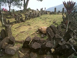
Gunung Padang is a megalithic site located in Karyamukti, Campaka, Cianjur Regency, West Java, Indonesia, 30 kilometres (19 mi) southwest of the regency seat or 8 kilometres (5.0 mi) from Lampegan station. The site is built of earth and stone at the top of an extinct volcano. It has become famous due to controversial carbon dating results which, if they had been confirmed, would suggest that construction began as far back as 20,000 BCE.[1] In 2013 the geologist suggesting these dates, Danny Hilman Natawidjaja (often referred to only as Danny Hilman), suggested that the site had been built as a giant pyramid by the inhabitants of Atlantis around 11,000 BCE.[2]
In a 2014 Kompas.com report, archaeologist Harry Truman Simanjuntak suggests that the constructions may have been built much more recently, perhaps sometime between the 2nd and 6th centuries CE.[3]
History
The existence of the site was mentioned in Rapporten van de Oudheidkundige Dienst (ROD, "Report of the Department of Antiquities") in 1914. The Dutch historian N. J. Krom also mentioned it in 1949. Employees of the National Archeology Research Centre visited the site in 1979 for a study of its archaeology, history, and geology.[citation needed]
Located at 885 metres (2,904 ft) above sea level, the site covers a hill in a series of terraces bordered by retaining walls of stone that are accessed by about 400 successive andesite steps rising about 95 metres (312 ft). It is covered with massive rectangular stones of volcanic origin. The Sundanese people consider the site sacred and believe it was the result of King Siliwangi's attempt to build a palace in one night.
At the end of June 2014, the Education and Culture Ministry declared Gunung Padang Megalithic Site a National Site Area, covering a total of 29 hectares (72 acres).[4]
On 1 October 2014, surveyors halted excavation activities temporarily due to these facts and recommendations:[5]
- A large structure is below the surface.
- A core zone site area has been confirmed.
- Many man-made artifacts have been discovered.
- The construction of the site spans four eras.
- A recommendation has been made to extend the survey, including a renovation concept, as well as conservation and management of the site.
The 2014 excavation has been criticized for being improperly conducted.[6]
- Gunung Padang was originally a natural volcano.
2012 survey
A survey conducted in 2012 showed the following:[citation needed]
- The site was dated 6,500 years BP (before present) by carbon radiometric dating at 3–4 metres below the surface (12,500 years at 8 to 10 metres below the surface), and the artifacts at the surface date to about 4,800 years BP.
- Based on geoelectric, georadar, and geomagnetic testing, at least up to 15 metres (49 ft) from the surface there is construction with large chambers.
- Unlike the south side with its 5 stone terraces, the east side has 100 stone terraces with width and height of 2 by 2 metres (6 ft 7 in × 6 ft 7 in). The west side also has stone terraces but is still covered by soil and bush, and the north side has a 1.5 metre-wide staircase, as well as terraces.
- The site area is approximately 25 hectares (62 acres), in contrast for example to Borobudur Temple, which occupies only 1.5 hectares (3.7 acres).
- Wall-side construction of the terraces is similar to that of Machu Picchu in Peru.
Criticism
Thirty-four Indonesian scientists signed a petition questioning the motives and methods of the Hilman-Arif team.[1] Vulcanologist Sutikno Bronto states that the site is the neck of an ancient volcano and not a man-made pyramid.[1] An archaeologist who did not wish to be named due to the involvement of the country's president who had set up a task force, said that: In archaeology we usually find the 'culture' first … Then, after we find out the artefact's age we'll seek out historical references to any civilisation which existed around that period. Only then will we be able to explain the artefact historically. In this case, they 'found' something, carbon-dated it, then it looks like they created a civilisation around the period to explain their finding..[1]
References
- Dipa, Arya (2014-09-24). "Archaeologists slam excavation of Gunung Padang site". thejakartapost.com.
External links
Devils Tower
| Devils Tower | |
|---|---|
| Matȟó Thípila (Lakota), Daxpitcheeaasáao (Crow)[1] | |
 | |
| Highest point | |
| Elevation | 5,112 ft (1,558 m) NAVD 88[2] |
| Coordinates | 44°35′26″N 104°42′55″WCoordinates: 44°35′26″N 104°42′55″W[3] |
| Geography | |
| Location | Crook County, Wyoming, United States |
| Parent range | Bear Lodge Mountains, part of the Black Hills |
| Topo map | USGS Devils Tower |
| Geology | |
| Mountain type | Laccolith |
| Climbing | |
| First ascent | William Rogers and Willard Ripley, July 4, 1893 |
| Easiest route | Durrance Route |
| Devils Tower National Monument | |
|---|---|
| Nearest city | Hulett, Wyoming |
| Coordinates | 44°35′26″N 104°42′55″W |
| Area | 1,346 acres (5.45 km2)[5] |
| Established | September 24, 1906[6] |
| Visitors | 499,031 (in 2017)[7] |
| Governing body | National Park Service |
| Website | Devils Tower National Monument |
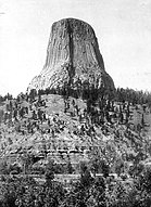
Devils Tower (also known as Bear Lodge Butte[8]) is a butte, possibly laccolithic, composed of igneous rock in the Bear Lodge Ranger District of the Black Hills, near Hulett and Sundance in Crook County, northeastern Wyoming, above the Belle Fourche River. It rises 1,267 feet (386 m) above the Belle Fourche River, standing 867 feet (265 m) from summit to base. The summit is 5,112 feet (1,559 m) above sea level.
Devils Tower was the first United States national monument, established on September 24, 1906 by President Theodore Roosevelt.[9] The monument's boundary encloses an area of 1,347 acres (545 ha).
Origin of name
The name Devil's Tower originated in 1875 during an expedition led by Colonel Richard Irving Dodge, when his interpreter reportedly misinterpreted a native name to mean "Bad God's Tower".[10] All information signs in that area use the name "Devils Tower", following a geographic naming standard whereby the apostrophe is omitted.[11]
Native American names for the monolith include "Bear's House" or "Bear's Lodge" (or "Bear's Tipi", "Home of the Bear", "Bear's Lair"; Cheyenne, Lakota: Matȟó Thípila, Crow: Daxpitcheeaasáao ("Home of Bears"[12]), "Aloft on a Rock" (Kiowa), "Tree Rock", "Great Gray Horn",[10] and "Brown Buffalo Horn" (Lakota: Ptehé Ǧí).[citation needed]
In 2005, a proposal to recognize several Native American ties through the additional designation of the monolith as Bear Lodge National Historic Landmark met with opposition from United States Representative Barbara Cubin, arguing that a "name change will harm the tourist trade and bring economic hardship to area communities".[13] In November 2014, Arvol Looking Horse proposed renaming the geographical feature "Bear Lodge" and submitted the request to the United States Board on Geographic Names. A second proposal was submitted to request that the U.S. acknowledge what it described as the "offensive" mistake in keeping the current name and to rename the monument and sacred site Bear Lodge National Historic Landmark. The formal public comment period ended in fall 2015. Local state senator Ogden Driskill opposed the change.[14][15] The name was not changed.
Geology
The landscape surrounding Devils Tower is composed mostly of sedimentary rocks. The oldest rocks visible in Devils Tower National Monument were laid down in a shallow sea during the Triassic.[citation needed] This dark red sandstone and maroon siltstone, interbedded with shale, can be seen along the Belle Fourche River. Oxidation of iron minerals causes the redness of the rocks. This rock layer is known as the Spearfish Formation. Above the Spearfish Formation is a thin band of white gypsum, called the Gypsum Springs Formation, Jurassic in age.[citation needed] Overlying this formation is the Sundance Formation.[16] During the Paleocene Epoch, 56 to 66 million years ago, the Rocky Mountains and the Black Hills were uplifted.[citation needed] Magma rose through the crust, intruding into the existing sedimentary rock layers.[17]
Geologists Carpenter and Russell studied Devils Tower in the late 19th century and came to the conclusion that it was formed by an igneous intrusion.[18] In 1907, geologists Nelson Horatio Darton and C. C. O'Harra (of the South Dakota School of Mines) theorized that Devils Tower must be an eroded remnant of a laccolith.[19]
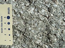
The igneous material that forms the Tower is a phonolite porphyry intruded about 40.5 million years ago,[neutrality is disputed][20] a light to dark-gray or greenish-gray igneous rock with conspicuous crystals of white feldspar.[21] As the magma cooled, hexagonal columns formed (though sometimes 4-, 5-, and 7-sided columns were possible), up to 20 feet (6.1 m) wide and 600 feet (180 m) tall.
As rain and snow continue to erode the sedimentary rocks surrounding the Tower's base, more of Devils Tower will be exposed. Nonetheless, the exposed portions of the Tower still experience certain amounts of erosion. Cracks along the columns are subject to water and ice erosion. Portions, or even entire columns, of rock at Devils Tower are continually breaking off and falling. Piles of broken columns, boulders, small rocks, and stones, called scree, lie at the base of the tower, indicating that it was once wider than it is today.[17]
Native American culture
According to the Native American tribes of the Kiowa and Lakota, a group of girls went out to play and were spotted by several giant bears, who began to chase them. In an effort to escape the bears, the girls climbed atop a rock, fell to their knees, and prayed to the Great Spirit to save them. Hearing their prayers, the Great Spirit made the rock rise from the ground towards the heavens so that the bears could not reach the girls. The bears, in an effort to climb the rock, left deep claw marks in the sides, which had become too steep to climb. Those are the marks which appear today on the sides of Devils Tower. When the girls reached the sky, they were turned into the stars of the Pleiades.[22]
Another version tells that two Sioux boys wandered far from their village when Mato the bear, a huge creature that had claws the size of tipi poles, spotted them, and wanted to eat them for breakfast. He was almost upon them when the boys prayed to Wakan Tanka the Creator to help them. They rose up on a huge rock, while Mato tried to get up from every side, leaving huge scratch marks as he did. Finally, he sauntered off, disappointed and discouraged. The bear came to rest east of the Black Hills at what is now Bear Butte. Wanblee, the eagle, helped the boys off the rock and back to their village. A painting depicting this legend by artist Herbert A. Collins hangs over the fireplace in the visitor center at Devils Tower.
In a Cheyenne version of the story, the giant bear pursues the girls and kills most of them. Two sisters escape back to their home with the bear still tracking them. They tell two boys that the bear can only be killed with an arrow shot through the underside of its foot. The boys have the sisters lead the bear to Devils Tower and trick it into thinking they have climbed the rock. The boys attempt to shoot the bear through the foot while it repeatedly attempts to climb up and slides back down leaving more claw marks each time. The bear was finally scared off when an arrow came very close to its left foot. This last arrow continued to go up and never came down.[23]
Wooden Leg, a Northern Cheyenne, related another legend told to him by an old man as they were traveling together past the Devils Tower around 1866–1868. A Native American man decided to sleep at the base of Bear Lodge next to a buffalo head. In the morning he found that both he and the buffalo head had been transported to the top of the rock by the Great Medicine with no way down. He spent another day and night on the rock with no food or water. After he had prayed all day and then gone to sleep, he awoke to find that the Great Medicine had brought him back down to the ground, but left the buffalo head at the top near the edge. Wooden Leg maintained that the buffalo head was clearly visible through the old man's spyglass. At the time, the tower had never been climbed and a buffalo head at the top was otherwise inexplicable.[24]
The buffalo head gives this story special significance for the Northern Cheyenne. All the Cheyenne maintained in their camps a sacred teepee to the Great Medicine containing the tribal sacred objects. In the case of the Northern Cheyenne, the sacred object was a buffalo head.[25]
N. Scott Momaday (Kiowa) was given the name Tsoai-talee (Rock Tree Boy) by Pohd-lohk, a Kiowa elder, linking the child to the Devils Tower bear myth. To reinforce this mythic connection, his parents took him there.[26] Momaday incorporated the bear myth as unifying subtext into his 1989 novel The Ancient Child.[27]
Post colonization history
Fur trappers may have visited Devils Tower, but they left no written evidence of having done so. The first documented Caucasian visitors were several members of Captain William F. Raynolds's 1859 expedition to Yellowstone. Sixteen years later, Colonel Richard I. Dodge escorted an Office of Indian Affairs scientific survey party to the massive rock formation and coined the name Devils Tower.[28] Recognizing its unique characteristics, the United States Congress designated the area a U.S. forest reserve in 1892 and in 1906 Devils Tower became the nation's first National monument.[29]
Climbing
As of 1994, climbing Devils Tower had increased in popularity. About 1.3% of the monument's 400,000 annual visitors climbed Devils Tower, mostly using traditional climbing techniques.[30] The first known ascent of Devils Tower by any method occurred on July 4, 1893, and is credited to William Rogers and Willard Ripley, local ranchers in the area. They completed this first ascent after constructing a ladder of wooden pegs driven into cracks in the rock face. A few of these wooden pegs are still intact and are visible on the tower when hiking along the 1.3-mile (2.1 km) Tower Trail at Devils Tower National Monument. Over the following thirty years many climbs were made using this method before the ladder fell into disrepair.
The first ascent using modern climbing techniques was made by Fritz Wiessner with William P. House and Lawrence Coveney in 1937. Wiessner led almost the entire climb free, placing only a single piece of fixed gear, a piton, which he later regretted, deeming it unnecessary.
In 1941 George Hopkins parachuted onto Devils Tower,[31] without permission, as a publicity stunt resulting from a bet. He had intended to descend by a 1,000-foot (300 m) rope dropped to him after successfully landing on the butte, but the package containing the rope, a sledge hammer and a car axle to be driven into the rock as an anchor point slid over the edge. As the weather deteriorated, a second attempt was made to drop equipment, but Hopkins deemed it unusable after the rope became snarled and frozen due to the rain and wind. Hopkins was stranded for six days, exposed to cold, rain and 50 mph (80 km/h) winds before a mountain rescue team led by Jack Durrance, who had successfully climbed Devils Tower in 1938, finally reached him and brought him down.[32][33] His entrapment and subsequent rescue was widely covered by the media of the time.[34]
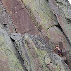
Today, hundreds of climbers scale the sheer rock walls of Devils Tower each summer. The most common route is the Durrance Route, which was the second free route established in 1938. There are many established and documented climbing routes covering every side of the tower, ascending the various vertical cracks and columns of the rock. The difficulty of these routes range from relatively easy to some of the most challenging in the world. All climbers are required to register with a park ranger before and after attempting a climb. No overnight camping at the summit is allowed; climbers return to base on the same day they ascend.[35][full citation needed]
The Tower is sacred to several Plains tribes, including the Lakota, Cheyenne and Kiowa. Because of this, many Native American leaders objected to climbers ascending the monument, considering this to be a desecration. The climbers argued that they had a right to climb the Tower, since it is on federal land. A compromise was eventually reached with a voluntary climbing ban during the month of June when the tribes are conducting ceremonies around the monument. Climbers are asked, but not required, to stay off the Tower in June. According to the PBS documentary In the Light of Reverence, approximately 85% of climbers honor the ban and voluntarily choose not to climb the Tower during the month of June. However, several climbers along with the Mountain States Legal Foundation sued the Park Service, claiming an inappropriate government entanglement with religion.[36][full citation needed][37]
Wildlife
Devils Tower National Monument protects many species of wildlife, such as white-tailed deer, prairie dogs, and bald eagles.[38][39]
In popular culture
The 1977 movie Close Encounters of the Third Kind used the formation as a plot element and as the location of its climactic scenes.[40][41] Its release was the cause of a large increase in visitors and climbers to the monument.[42]
National Register of Historic Places
Four areas of Devils Tower National Monument are on the National Register of Historic Places:
Gallery
Ponderosa pine forest east of Devils Tower
US Geological Survey picture of Devils Tower
See also
References
- Carlson, Allen (2009). Nature and Landscape: An Introduction to Environmental Aesthetics. Columbia University Press. p. 122. ISBN 978-0231140416.
Bibliography
- Marquis, Thomas B. (2003). Wooden Leg: A Warrior Who Fought Custer. Lincoln, Neb.: University of Nebraska Press, Bison Books. ISBN 0-8032-8288-5. OCLC 52423964, 57065339. Wooden Leg: A Warrior Who Fought Custer at Google Books.
- Darton, Nelson Horatio (1909). Geology and water resources of the northern portion of the Black Hills and adjoining regions in South Dakota and Wyoming U.S. Geological Survey Professional Paper 65 (1909). doi:10.3133/pp65
External links
| Wikimedia Commons has media related to Devils Tower. |
| Wikivoyage has a travel guide for Devils Tower. |
- Devils Tower National Monument — National Park Service
- The short film Tower of Stone is available for free download at the Internet Archive. — public domain, produced by National Park Service.
- 450 megapixel high-resolution photo of Devils Tower
- IUCN Category III
- Devils Tower National Monument
- Rock formations of Wyoming
- Volcanoes of Wyoming
- Archaeological sites in Wyoming
- Black Hills
- Climbing areas of the United States
- Kiowa
- Lakota mythology
- Religious places of the indigenous peoples of North America
- Monoliths of the United States
- Sacred mountains
- Volcanic plugs of the United States
- Volcanism of Wyoming
- Paleocene volcanism
- Properties of religious function on the National Register of Historic Places in Wyoming
- Natural history museums in Wyoming
- Museums in Crook County, Wyoming
- Protected areas of Crook County, Wyoming
- National Park Service National Monuments in Wyoming
- American folklore
- 1906 establishments in the United States
- Landforms of Crook County, Wyoming
- National Register of Historic Places in Crook County, Wyoming












No comments:
Post a Comment